t
The Group's aim is to identify, survey, protect and promote geological and geomorphological sites in the former County of Avon - the modern unitary authorities of Bath and North East Somerset, Bristol, North Somerset and South Gloucestershire. RIGS are selected for their educational, research, historical and aesthetic value.

Friday, 28 September 2012

The Geology Collection University of Bristol goes OnLine


The School of Earth Sciences at the University of Bristol holds a collection of over 100,000 mineralogical, paleaontological and petrological specimens which were donated to the School over the past 100 years. Some iconic specimens are an original map by William Smith, a near complete and mounted skeleton of a sabre-toothed cat, fossilised bones of early dinosaurs and an array of minerals from now inaccessible mines in the UK. The collection also contains over 1500 type fossils and published specimens, a unique and valuable resource to researchers worldwide.

Rhodochrosite from Argentina (BRSUG B2502)
 
Over the past decade efforts have been made to record and document the collection to unlock its scientific and educational potential. The current digitisation project OnLine aims to improve remote access to the wealth of geological specimens in the collection. The project includes the design of a brand new website as well as the development of an extensive photo archive and a searchable online database.

A taster of the future website of the Geology Collection University of Bristol, going live in autumn 2012.


Claudia Hildebrandt, Collections Manager: "With the valuable help of students and volunteers we have now digitise over 60,000 specimen records for online publication. We collected details from registers, card catalogues, collectors’ field notebooks and the specimens themselves and merged all information into a comprehensive database. Additional funding from JISC (as part of the BRICOLAGE project) allowed us to employ a student who reorganised taxonomic, stratigraphic and geographic entries and ensured consistency across the whole database.”

“We have also started to add recently taken photographs of specimens to the database. This will offer users a look behind the scenes of our stores.”

Volunteer Charlie Navarro editing photographs of Cretaceous chalk fossils.


Once the website goes live in autumn 2012 the OnLine project will enter its second phase.

Claudia: “We aim to create links between specimens and relevant scientific publications and publish a tool that visualises the geographic distribution of all our UK specimens. We will also add a feedback function to the catalogue which will allow amateurs and specialists to comment on specimens and send enquiries.”

"And this is just the beginning. Parts of the collection need to be revisited to update taxonomic and stratigraphic information. We also plan to highlight the historic value of our collection. Many honorable and well know geologists donated their samples to the Geology Collection, from local fossil collectors to internationally known palaeontologist. We would like to dig deeper and reveal the people behind our collection and the extraordinary journeys some of our specimens have been on.”

If you would like to find out more about the Geology Collection follow us on Facebook.

Claudia Hildebrandt

Friday, 21 September 2012

Gryphaea arcuata


Fossils from the Avon RIGS area.
Gryphaea arcuata

Please read the geologist's code here:-  


Name                     Gryphaea arcuata
Phylum                      Mollusca
Class                      Bivalvia
Order                     Pterioidea
Family                    Gryphaeidae
Genus                     Gryphaea
Species                  G. arcuata


Gryphaea arcuata showing 'toenail' and ‘lid’.

Photo credit – Richard Kefford

Other, larger, pictures of this fossil can be found here


Source rock     Lias Group

Age range             Triassic/Jurassic,  Rhaetian 203 Ma – Aalenian 171 Ma

Locations              Several outcrops in area. The one pictured above was found at Hock Cliff in the Sinemurian strata of the Lower Jurassic from about 194 Ma.    SO 722 094

Please note that there are additional risks at this site which include:- unstable cliffs, difficult rocky and muddy foreshore, fast flowing currents and tides which can reach parts of the cliff. 
Check tide times before venturing onto foreshore.
Please see comment below from Andrew Mathieson.


Description of fossil

Gryphaea arcuata is an extinct species of foam oyster, a bivalve mollusc 
in the family Gryphaeidae. Commonly known as Devil’s Toenails.

Their temporal range is from late Triassic to early Cretaceous but their fossils are most commonly found in Jurassic strata.

These oysters lived on the sea bed in shallow waters, possibly in large colonies. The complete fossils consist of two articulated valves; a larger gnarly-shaped shell ( the “toenail” ) and a smaller, flattened shell, the “lid”. The soft parts of the animal occupied the cavity between the two shells, just like modern oysters. The shells also feature prominent growth bands. The larger, curved shell sat within the mud on the sea floor. These shells are sometimes found in fossil plates along with Turritella, Pentacrinites, Plagiostoma, clams, and sometimes shark’s teeth and fossilized fish scales.

Description of source rock in area – Lias Group.

                   Paleoenvironment
Nearing the end of the Triassic, the landmasses remain united, in the form of the supercontinent Pangea. The Tethys Ocean is actively spreading. The British Isles are at about 300 North.
        During the early Jurassic, Pangea breaks up resulting in Gondwana and Laurasia separating as the South Atlantic starts to rift open. The British Isles continue to drift Northwards to about 400 North. Lithospheric extension and passive rifting occurs to the East, starting to form the North Sea and to the West where the North Atlantic will later open.
        During the early Jurassic, sea levels continue to rise across the British Isles so Triassic desert sediments are replaced by a cyclic succession of fossiliferous dark grey marine mudstones, marls and limestones.

                   Lithology
        Predominantly grey, well bedded, marine calcareous mudstone and silty mudstone; thin tabular or nodular beds of argillaceous limestone, particularly in the lower part; thicker units of siltstone and sandstone, particularly in the upper part, and ironstone, particularly in the middle part. Marginal limestone facies also occur.

Richard Kefford


                  References

             - British geological Survey – Lexicon of rock units


Friday, 14 September 2012


RIGS of the Month [September ] – Redcliffe Caves, Bristol


RIGS of the Month – September 2012.
Recliffe Caves – Bristol


Entrance to caves on Phoenix Wharf.

There are more pictures here.

Location: Phoenix Wharf, near Redcliffe Parade ST 589 723

This area has been a designated RIGS since 1986.

Access: The caves are owned by Bristol Council but access is controlled by the Axbridge Caving Group, who open the caves for tours annually during the Bristol Open Doors Day each September. They can also be approached for Group tours at other times, see here for details:


Risks: Low roofs, rough ground. Hard hats, stout footwear and torches advised. 

Friends Burial Ground showing cliff near hermitage.

The caves are not natural caves but excavated tunnels into the Redcliffe Sandstone. They were originally excavated to provide sand for glass making and have been used over the years for many different storage purposes.
The foundations of what is now the Mercure Hotel can be seen underground, in the caves.
The sandstone underground is massive with little jointing and no cross- bedding can seen although examples can be seen in this formation at the exposure in the Friends Burial Ground adjacent to the hermitage entrance.

Efflorescence from roof surface

There is surface efflorescence in several areas from the roof, which is assumed to be the decalcification referred to in the Bristol memoir.
The headroom varies around a norm of 2m and there is estimated to be some 6m of sandstone between the cave roof and the ground surface above.
The floor is mostly composed of dumped ash and slag – from the old lead works – that have consolidated over time.
Tree roots have penetrated in some areas.

Cross bedding near hermitage

The caves are cut into the Triassic Redcliffe Sandstone Member.

Redcliffe Sandstone Member ( RESA )

Lithological description:
Sandstone, distinctive fine to medium grained, deep red, calcareous and ferruginous. Commonly decalcified at shallow depths below the surface, giving rise to an uncemented sand.

BGS Computer code:
RESA

Definition of Lower Boundary:
Unconformable, at the abrupt base of the red sandstones of the Redcliffe Sandstone Member overlying sandstones and mudstones of Late Carboniferous age. 

Definition of Upper Boundary:
Conformable and gradational, with interdigitation between red sandstone of the Redcliffe Sandstone and reddish-brown mudstone of the Sidmouth Mudstone Formation (undivided).

Thickness:
Up to 65m

Geographical limits:
Crops out in the Bristol area between Bedminster and Winterbourne.

Parent Unit:
Sidmouth Mudstone Formation

Group:
Mercia Mudstone Group

Age:
Triassic

Stratigraphic setting:
Following the Variscan orogeny at the end of the Carboniferous Period, erosion stripped off some of the Coal Measures during the Permian so the RESA was laid down unconformably on the irregular remnant Carboniferous landscape, diachronous with the marginal facies of the Mercia Mudstone Group. RESA was deposited in an elongate depression between Bedminster and Winterbourne and locally exceeds 50m in thickness. The RESA passes laterally into red mudstones and is locally interdigitated with Mercias Mudstone Marginal Facies ( MMMF ). The best exposures of RESA are found in cliffs along the Avon in Redcliffe, the eponymous district of Bristol, and in the New Cut along Coronation Road, Southville.

Applied geology:
RESA was used for glassmaking, the glass being used to make bottles for the thermal water from the five Bristol hot springs which were then largely exported.
The RESA is an aquifer which was an important source of water for Bristol in the past until contamination from local cess pits and burial grounds resulted in several epidemics.

Ground conditions:
In some areas the RESA has become decalcified, losing its cement and becoming friable and difficult to handle when wet. Changes in groundwater regimes can be responsible for this decalcification process, which in turn can cause local subsidence. Weathered RESA , when used for fill material has also been known to provide poor support for buildings.

References:
BGS Lexicon           -           http://www.bgs.ac.uk/lexicon/
BGS map      2004   -           England and Wales sheet 264 – Bristol – Solid and Drift
BGS Memoir 2002   -           Geology of the Bristol District
Memoir 1949 / 2000 -           Geology & scenery of the West of England – AE Turner & N Chidlaw                         
Cave web site         -            http://www.bristoltours.com/Redcliffe.htm
Photo credits          -            Richard Kefford

Richard Kefford

Friday, 7 September 2012

Nailsea Environmental & Archaeological Team – NEAT

Nailsea Environmental & Archaeological Team


NEAT - Aims and Objectives

Nailsea Environmental & Archaeological Team – NEAT, was set up in September 2004 to undertake archaeological research in the Nailsea area, including Tickenham, Wraxall, Backwell, Chelvey and Brockley.
     Our aim is to carry out fieldwork to find new archaeological sites, record existing sites and to augment the North Somerset Historical Environment Record, in conjunction with the County Archaeologist. 

     The methods used include land survey, geophysical survey, map regression and reference to local archives and involve work with other similar groups in North Somerset. 

     In addition, NEAT has carried out a survey of dry stone walls in Nailsea, recorded the age of buildings and recorded the hedges in the area. There is research ongoing into other aspects of our local environment. 

     During 2011 NEAT established a geology group with the initial aim of establishing ‘geotrails’ around the area to show and explain the local geology. It is intended to complete the geotrails project and publish a guidebook in 2012.

     There is a live link to the NEAT web site in the right hand column on this blog home page.

David Sowdon

Friday, 31 August 2012

Inspiring the next generation

Kate Hibbert, University of Bristol
Guest blogger Kate Hibbert is a PhD student in Earth Sciences at the University of Bristol. She is also a STEM ambassador and is interested in how academics can inspire the next generation of scientists.
 
Postgraduate students at the University of Bristol are heavily involved with outreach teaching activities, visiting Bristol schools to talk about various topics in Earth Sciences. Volunteers are co-ordinated by the STEM ambassador scheme. The aim of the scheme is to get more young people involved with STEM subjects (Science, Technology, Engineering and Maths) and it effectively acts as a matchmaker between schools and willing expert volunteers. The network includes professionals as well as university students. STEM ambassadors go in to schools and might, for example, run a workshop, provide mentoring for a small group, talk to an after school club or take part in a careers fair.

Bristol students have been involved in several projects, including the Bristol Dinosaur Project. Thousands of school children of all ages have had a visit from the Dinosaur Project team, giving them the opportunity to learn about this dinosaur unique to the Bristol region in an interactive workshop. The session also involves a life-sized jigsaw of the Bristol dinosaur and handling real fossil specimens, an activity that never fails to spark the imagination.

Primary school children getting some hands-on experience of life as a palaeontologist. Photo credit: Bristol Dinosaur Project

But it’s not just dinosaurs that can inspire children – workshops run by Bristol Earth Sciences PhD students have covered a wide range of topics, from the rock cycle to volcanoes to meteorites. A workshop might involve handling rock specimens, squashing plasticine to learn how a metamorphic rock is made, or using the classroom to reconstruct the scale of the solar system.

Teaching the rock cycle using crayons. Photo credit: http://mesmrswhitesclass.blogspot.co.uk

The benefits of these school visits are not limited to imparting knowledge about the topic covered, but also come from allowing children to meet ‘real-life scientists’, helping to break down some of the stuffy scientific stereotypes and encourage more people into science subjects and science careers. The rewards for volunteers are great, not least giving confidence in public speaking. If you can successfully hold the attention of a classroom of 10 year-olds, then giving a professional presentation seems significantly less daunting! 
Three lots of fossil finds for local school children. Photo credit: Bristol Dinosaur Project

Kate Hibbert

Links:

If you’re interested in the STEM ambassador scheme or want to arrange for an ambassador to visit your school: http://www.stemnet.org.uk/content/stem-ambassadors

A previous blog post about the Bristol Dinosaur: http://avonrigsoutcrop.blogspot.co.uk/2012/02/bristol-dinosaur-project.html

Friday, 24 August 2012


The William Smith Stone Column


The William Smith Stone Column near Wellow

Photo credit Andrew Mathieson

In 2006 the transport charity Sustrans commissioned the sculptor Jerry Ortmans to design and construct an art installation to celebrate the work of William Smith, the “Father of English Geology”. This Stone Column was to be in natural stone and to be installed near the village of Wellow, a few miles south of Bath, and along Route 24 of the National Cycle Network. The section of the Route from Bath to Frome has been called the Colliers Way and it provides new access to both the disused Somerset and Dorset railway line and the original route of the southern branch of the Somersetshire Coal Canal, which Smith worked on between 1793 and 1799.

        The siting was intended to link Smith's understanding of the local geology with his work on the survey and construction of the canal, which gave him so much evidence for his ground breaking understanding of stratigraphy and the use of fossils to identify beds of rock. In fact, although most of this southern branch of the canal was excavated, the company ran out of funds to build a flight of locks and it was never connected to the rest of the canal by water. Instead coal was carried along the original towpath on a horse-drawn railway and transferred to boats on the main canal near Midford.

        The design of the sculpture was based on Smith's account of the sequence of local rocks which he drew up in his famous Table of Strata in 1799, shortly after his dismissal from the Coal Canal Company. Seven large blocks of local rock were chosen and these were arranged into a vertical structure in their order of succession. Ortmans worked with local geologist Simon Carpenter to select suitable stone from a number of working quarries in the West of England, and they range from Carboniferous Pennant Sandstone up to Cretaceous Chalk.

        Sustrans also commissioned two information panels to be installed along the Colliers Way to help visitors better understand Smith's work in terms of the local geology and his work on the construction of the Coal Canal. One was placed beside the Stone Column and it concentrates on the local geology and Smith's work and the history of the Canal. It features a little-seen engraving of Smith in 1807, when he was aged 38, and emphasizes that the canal was one of the most prosperous in the south of England. Unfortunately there is little evidence of the canal nearby since its route was mostly destroyed by the construction of the railway.

        The second information panel is just south of the Midford railway viaduct, and this mainly deals with the various forms of transport which once existed nearby. There is a photograph of a train on both the Somerset and Dorset and the Limpley Stoke – Camerton lines in 1958, when the latter railway was being scrapped. The illustration for the Coal Canal is a photograph of Midford Weigh House which was taken in about 1890. An extract from a geological map of Smith's is also included. This was published in 1820, several years after his famous geological map of England and Wales, and Smith included all the existing canals and railways of the time.

        Although these installations are a distance from the sites most people associate with William Smith (Tucking Mill, Rugborne House, etc.), they add new ways of commemorating his pioneering contribution to geology and in addition are set in an area of attractive Inferior Oolite and Fullers Earth countryside which Smith would have known well.

Andrew Mathieson

Friday, 17 August 2012

Box Rock Circus

Box Rock Circus

http://www.boxrockcircus.org.uk

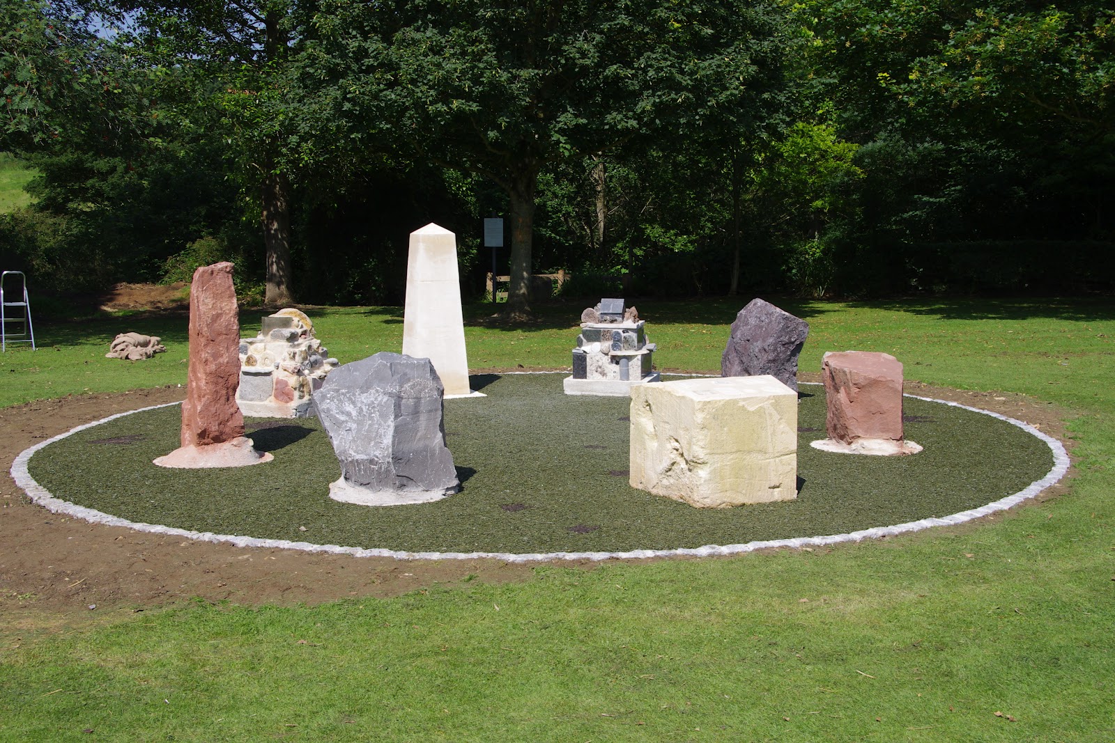
FIG 1: The Box Rock Circus. The standing stones, from left to right around the perimeter, are Permo-Triassic New Red Sandstone, Carboniferous Limestone, the Jurassic Box Bath Stone table, Devonian Old Red Sandstone and Silurian andesite. Photo credit Charles Hiscock
A larger version of this and all the other photos can be seen here

There is the old saying that ‘The sun shines on the righteous’ and this was particularly true on Thursday 9th August 2012 when the sun blazed down for one of the few days of Summer 2012 at the village of Box, near Corsham, Wiltshire. At 11am on that very warm morning, the good and great (and righteous!) of Box gathered at the village recreation ground for the unofficial unveiling of the ‘Box Rock Circus’, carried out by the Chairman of the Box Parish Council, Pauline Lyons, to mark completion of the construction with many villagers and children and representatives of the press in attendance.
‘Box Rock Circus’, the brainchild of well-known local geologist and Earth Science Educator, Elizabeth Devon, is a circular arrangement of large stone blocks and rock sculptures designed to tell the history of the rocks that we can see in our environment, enabling people to touch, examine, climb on and over or just admire the originality of thought that has produced this superb feature.

FIG 2: Elizabeth Devon, who had the original idea and designed the Box Rock Circus, stands beside the Bath Stone obelisk. Photo credit: Charles Hiscock 
The circular array contains 5 large blocks of rock donated from quarries in differing geological areas. The Carboniferous Limestone block, packed with fossil corals, came from Wickwar Quarry while the volcanic Silurian andesite originates from Moon’s Hill Quarry at Stoke St Michael on Mendip. Two large blocks of red sandstone represent the Devonian Old Red Sandstone, from Black Mountain Quarries of Herefordshire, and the Permo-Triassic New Red Sandstone from Capton Quarry near Williton, Somerset. Local rocks are used for the ‘table,’ cut from the Jurassic Hartham Stone, and the beautifully carved obelisk (fig. 2) from Jurassic Box Ground Bath Stone Quarry, the latter illustrating the importance of this fine rock in the history of Box. The quarry has supplied fine Bath Stone for 1000 years but was closed for 60 years until it was recently reopened. Inset in the top of the ‘table’ rock are moulds of a range of fossils (fig. 3) – Silurian trilobites, Jurassic ammonites, a Carboniferous dragonfly, the first Cretaceous bird Archaeopteryx, starfish, a fossil worm trail and a fish - that children (of all ages!) can reproduce in the same way as brass rubbings. Also on the table is the badge of the Geologists’ Association which sponsored the fossil rubbings through the Curry Fund. 
FIG 3: Inset in the top of the 'table' rock. Moulds of a range of fossils including Silurian trilobites, Jurassic ammonites, a Carboniferous dragonfly, the first Cretaceous bird Archaeopteryx, starfish, a fossil worm trail and a fish. Photo credit: Charles Hiscock 

The sculpted blocks are built up from specimens of different rocks and are intended to be climbed over by children as well as examined for their content of rock types. One is composed of sedimentary rocks and fossils sourced locally and from further afield, topped by a polished block of Purbeck Marble sitting on a specimen of fossil ripples (fig. 4).

FIG 4: The sedimentary rocks and fossils sculpture, topped by a block of Purbeck Marble. Photo credit: Charles Hiscock

The crystalline block contains specimens of igneous and metamorphic rocks, many as polished slabs as used for kitchen worktops and, completing the top, a sculpture of a tiny house built from slates, surrounded by pieces of lavas and a volcanic bomb (fig. 5).
FIG 5: The crystalline rock sculpture, including  slates, pieces of lavas and a volcanic bomb . Photo credit: Charles Hiscock

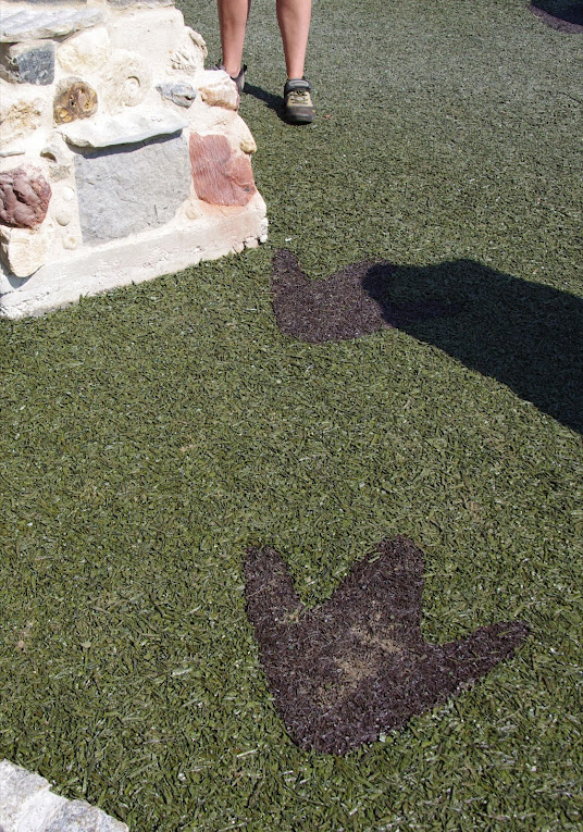
The rocks, obelisk and sculptured blocks are set in concrete, pinned with steel rods to the base and surrounded by a greenish rubbery matrix made from recycled tyres providing a soft play area for children. Made from the same material are two sets of dinosaur footprints, coloured black which cross the circular area (fig. 6). The outside perimeter is made from granite setts which will, in due course, be painted with red marks to show the geological timeline and how life only evolved very recently. In fig 01, the sculpted blocks stand either side of the obelisk, the sedimentary rocks and fossils on the left while the crystalline rocks stand on the right. The standing stones, from left to right around the perimeter, are Permo-Triassic New Red Sandstone, Carboniferous Limestone, the Jurassic Box Bath Stone table, Devonian Old Red Sandstone and Silurian andesite.
FIG 6: Dinosaur footprints across the Circus. Photo credit: Charles Hiscock

The project has received the backing of Box Parish Council and local organisations and been funded by a Landfill Communities Fund grant from the Hills Group Ltd. Construction of the Circus was carried out by a team of skilled craftsmen managed by stonemason Marcus Mitchell. The celebration on that sunny Thursday morning marked the completion of the construction work but there is more to be done such as the red ‘timeline’ to be painted, with one year representing the age of the earth and an interpretation board is to be set up. 

The website - http://www.boxrockcircus.org.uk is to be updated to give information about the rocks and fossils and fact sheets and a childrens’ quiz will be downloadable and also available in the village. 

Elizabeth Devon will be very happy to explain the Rock Circus and can be contacted on the Earth Learning website elizabeth@earthlearningidea.com. The official opening is to be held later in the year on a date yet to be agreed.

Charles Hiscock