t
The Group's aim is to identify, survey, protect and promote geological and geomorphological sites in the former County of Avon - the modern unitary authorities of Bath and North East Somerset, Bristol, North Somerset and South Gloucestershire. RIGS are selected for their educational, research, historical and aesthetic value.

Thursday, 26 July 2012

Geology in the West Country blog

Have you visited the Geology in the West Country blog?

This blog's main purpose is to publicise talks, field trips and events organised by West Country geological organisations. It also includes links to blogs and webpages of similar groups from around the UK. Discussion is encouraged and anything of general geological interest is included. Latest stories include Rock Circus in Box takes shape and Chemical ghost of 120million years-old bird.


There is a live link to the Geology in the West Country on the Outcrop homepage so that you can keep up to date with what is happening in our region.


Friday, 20 July 2012

Gypsum (CaSO4 - 2H2O)

Minerals of the Avon region 
Gypsum (CaSO4 – 2H2O)

Colour:    
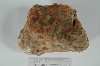
               White but may also be clear, or stained pink or orange                       depending on the percentage of included iron minerals. One polymorph – Desert Rose – may be brown because of included sand.

Polymorphs:
                Selenite ( Serenity )
                Satin Spar
                Desert Rose
                Alabaster (Saccharoidal )

Crystal system: 
                May be tabular, prismatic, acicular, fibrous, granular or             massive.

Specific gravity: 
                2.31 – 2.33

Hardness: 
                1.5 – 2 on the Moh scale

Group:
                Gypsum is a sulphate group evaporite mineral

Location: 
                Aust Cliff*.

                Please follow the Geologist's Code here.


Gypsum - Satin Spar
BRSUG B2317


Gypsum - Selenite
BRSUG B6236 


Gypsum - Desert Rose
BRSUG B3472


Gypsum - Alabaster
BRSUG B3932

The four pictures above are from the Geology Collection, University of Bristol. Larger pictures are here.

Paragenesis
There are very large deposits in the UK, the biggest is in East Sussex, with several seams in the Jurassic Purbeck beds. There are others in Staffordshire, Cumbria and Yorkshire. Gypsum is soluble in water but is unusual in that it becomes less soluble as the temperature rises. The deposits formed as seas or saline lakes dried out. It normally occurs as a massive rock or as crystals but can also form on the surface, as sand, where it is exposed to strong winds, such as the White Sands Monument in New Mexico.

General
        The Fauld gypsum mine in Staffordshire was the location of the biggest conventional explosion in either of the two world wars. in 1944, 3,500 tonnes of explosive blew up , killing 77 people and forming a crater 300ft deep.
         Because of its solubility in water and the fact that there are many shallow gypsum seams under Ripon, the city is known for an average of one subsidence event per year where solution cavities in the gypsum migrate to the surface and cause holes to open up. Details here.
         

Local exposures
        The best known local exposure of gypsum is at Aust Cliff*. The mineral occurs as both irregular masses and geodic nodules in the Mercia Mudstone. Here, in its alabaster massive form, it has the sugar lump or saccharoidal appearance, white or pink in colour.
It also occurs in secondary concentrations at the contact between the mudstones and underlying beds, as the ‘Satin Spar’ fibrous form which is invariably pure white.  

Uses
        Gypsum ( Alabaster ) was used in Somerset for ecclesiastical carvings but its main use now is for the production of dry lining boards for the building industry.
        It is also used as a soil conditioner for heavy, poorly draining, soils where the included sulfur (c. 15%) also aids plant growth by reducing the alkalinity. 
        It is a small constituent of Portland cement where the proportion controls the set time. The gypsum for this use in the UK invariably comes from the Sussex mine. It is said, by the Sussex miners, that every house built in the UK since about 1900 contains some gypsum from their mine.
        It also, of course, has a medical use as ‘plaster of Paris.’
        A side effect from the work to reduce the quantity of sulfur dioxide emitted from power stations is that a great deal of gypsum is produced by the desulfurisation process and so reduces the quantity required to be mined. This has, conversely, resulted in an increase in demand for calcium carbonate in the form of Limestone. The chemical reaction is
CaSO3 (solid) + H2O (liquid) + ½O2 (gas) → CaSO4 (solid) + H2O.
Further details here

Richard Kefford


*Aust Cliff is a SSSI and removal of specimens from the cliff face is both hazardous and illegal.

References:

Geology Collection, University of Bristol.


Friday, 13 July 2012

RIGS of the Month [July] - Cliff Quarry, Compton Martin


RIGS of the Month – July 2012
Cliff Quarry – Compton Martin

Dedicated to the work of Cliff Salter.


General view of Cliff Quarry East face
Picture credit Richard Kefford
A larger picture here.

Geological map showing location of Cliff Quarry.
Picture credit - BGS.
                                                              A larger picture here

Gallery of quarry, fossils and crystals here.
Picture credits Richard Kefford.


Please follow the Geologist's code.
http://www.brerc.org.uk/rigs_site/geologists_code.htm


Location: Near Compton Martin ST 541 568

Access: Turn South into lane in Compton Martin called ‘The Coombe.’ Follow lane to end and then follow short section of footpath ahead up into Compton Wood where Cliff Quarry is on the left. Parking is limited in the village.

Risks: Keep away from rock faces. Hard hats should be worn.

Topography: Rough ground, steep slopes and unstable cliff faces.


Oxwich Head Limestone at East Cliff Quarry. 
Picture credit Richard Kefford.


A larger picture here

General description
        There are two parts of Cliff Quarry.  Access is better at the East as the West Quarry is overgrown.

       The East Quarry is adjacent to the 36 mile (58 km) ‘Limestone Link’ footpath. This path connects the Carboniferous Limestone of the Mendip Hills with the Jurassic Limestone of the Cotswolds and so bridges more than 100 million years of geological time.


       The quarry was used to supply hard road stone but was closed in 1956 as the big Eastern Mendip quarries had better transport links to the main markets in the South East of England.


        Slightly to the East at ST 543 566 are the Compton Martin ochre mines.
Note.
        The ochre mining industry of the Avon RIGS area will be the subject of a future feature on this blog.

Geological context.
        The quarry is cut into the Oxwich Head Limestone (previously known as Hotwells Limestone) which was deposited in a shallow shelf sea during the Asbian – Brigantian  stage of the Early Carboniferous, 327 – 334 million years ago. The Southern part of the British Isles then lay just South of the equator. It had a tropical seasonal climate, probably driven by monsoons.

        The upper part of the quarry exposes Triassic Dolomitic Conglomerate rocks of the Mercia Mudstone Group. These form a drape of varying thickness around most of the Mendips. They also form infilled wadis that were cut by flash floods during arid Triassic times. The adjacent ochre mines were developed in this formation.

        The quarry is located on the North Eastern limb of the Blackdown pericline which is one of four that are set en echelon to form the structure of the Mendip Hills. 


        The rocks in the quarry dip about 400 to the North East. The strata of the Blackdown pericline dip more steeply to the North than to the South as it is an asymmetric anticline.


        The Oxwich Head Limestone Formation is up to 183 m thick in the area of the quarry. The type section is at Oxwich Head on the Gower. It is part of the Pembroke Limestone Group.


A      Cross section of Blackdown Pericline.      B
Picture credit - BGS


A larger picture here
                                 
Key to geological units on cross section. B à A

MMG -       Mercia Mudstone Group
CM    -       Coal Measures
DCG  -       Dolomitic Conglomerate - can be seen in quarry
QSG  -       Quartzitic Sandstone Formation
OHL  -       Oxwich Head Limestone - can be seen in quarry
CHI   -       Chinastone
CDL   -       Clifton Down Limestone
ChO  -       Cheddar Oolite Member
ChL   -       Cheddar Limestone Member
BO    -       Burrington Oolite Subgroup
VL     -       Vallis Limestone
BRL   -       Black Rock Limestone Subgroup
AvG   -       Avon Group ( Lower Limestone Shales.)
PO    -       Portishead Formation ( Old Red Sandstone )


Scientific importance
        This quarry is important because of the previous fossil content and the knowledge that this has added of the geology of this early part of the Carboniferous. This includes the discovery of a new species.


        The work was carried out on the fossils by Cliff Salter, who lived in Compton Martin. His collection of fossils is now held by the British Geological Survey (BGS) at Keyworth, Notts..

        This work has been recorded by Murray Mitchell and published by the Mendip Society.
   
        The many fossils that have been found in a section of this formation in the past are listed here pps 489 - 490

        A scientific paper based on the work carried out by Cliff Salter is here. It describes a new species, Cyclus Martinensis. It is named after the village of Compton Martin. See picture on page 489 here

          A common coral fossil called Lithostrotion ( Siphonodendron ) can be found in this quarry.

      There is some further information on the implications of Cliff Salter's research here and here reproduced from  'Thornbury Geology Group Newsletter February 2012'. 
      
There is also a paper here that follows on from this.


The above texts, following on from Cliff Salter's work, show that the existing numbers of fossils from the Carboniferous seas may be badly skewed and may result in parts of the palaeontology text books being rewritten.


Acknowledgements.


Thanks to Richard Ashley and Tarquin Bolton for their advice on identification of the fossils in the gallery.


References

The Salter Collection, from Cliff Quarry. Murray Mitchell. The Mendip Society.


A Walker’s Guide to the geology and lanscape of western Mendip. 2008. Andy Farrant. BGS.


Thornbury Geology Group Newsletter February 2012.


Richard Kefford. July 2012.


Friday, 6 July 2012

Avon Wildlife Trust

In the first of a new series, we catch up with local groups who are involved in geoconservation in the Avon region. First up, Avon Wildlife Trust.


From belemnites & brachiopods to bats & bullfinches...

Avon Wildlife Trust is committed to working for people and wildlife in the local area, and we manage 35 nature reserves, some of which are also sites with outstanding geological features. One reserve which has been at the centre of our recent 'Bats for Bath' project is Brown's Folly.

Brown's Folly, Bathford. Photo credit: Avon WT
Browns Folly Nature Reserve is a Special Area of Conservation (SAC) and Site of Special Scientific Interest (SSSI) that has rare calcareous grassland habitats, unique geology, ancient woodland and a cave system with fantastic bat populations, with 12 of Britain’s 18 Bat species having been recorded here.  The caves are the remnants from mining the local oolitic limestone which was extracted for building material, and which is known locally as 'Bath Stone'. Oolitic limestone gets its name from the spherical particles or 'ooids' it contains. This word comes  from the Greek word for 'egg' because ooids are thought to resemble fish eggs. You can see fossils  in the exposed stone - thick shelled bivalves such as Trigonia, found today in the Pacific, along with brachiopods, ammonites and belemnites which once swam in the sea which covered this area 170 million years ago.

Oolitic limestone hand specimen (left) and thin section (right). Photo credit: http://www.earthscienceeducation.com

The stone was used for building in Roman times, but intensive mining of the limestone beds in the valley was carried  out from the 17th to the early 20th century. The characteristic stone was used for the construction of most of Bath's famous buildings, as well as Buckingham Palace and many stately homes across the country. The different mines, which were driven in to the rock in the  area, stretched for many miles and contained stables, cart-roads and tramways. Stone was extracted by the 'room and pillar' method, by which chambers were mined, leaving pillars of stone to support the roof.  By the time the mines closed down in 1930 there were over 300 acres of interconnecting underground workings and tunnels, which were used for storing ammunition and government  records during the Second World War.

Bats are very fussy about their roosting sites - they need somewhere with stable temperature and ventilation levels, and the old mine tunnels under the woodland seem to suit them very well. The huge size of the mines means that areas deep down are less affected by outside variations in climate - a perfect spot to hibernate for the winter months. The Trust has installed bat grilles on the entrances of the mines in the woodland to make sure that the bats remain at peace within their hilly homes. Bats are protected by law, and the grilles also prevent access to the mines - protection for people as well as preserving peace for the bats. In spring and summer when the bats awake and come out to feed at dusk, the grassland glades of the reserve are rich with insects right on their doorstep.

Greater horseshoe bat - just one of the twelve species recorded in the caves at Brown's Folly. Photo credit: Avon WT
Brown's Folly in Bathford is one of our most popular reserves that receives around 5000 visitors each year with most people enjoying the fantastic views from the grassland plateau across to Bath and the surrounding area, and talking long walks through the ancient woodland full of rocky fissures, giant veteran trees, mosses and ferns, and open glades that all help support the bats roosting in the caves.

You can read more about Brown's Folly and other Trust nature reserves here.

Pat Ellingham
(Avon WT Director of Communications and Development)


Look out for more information on the geology of Brown's Folly - it is soon set  to feature on the blog as a RIGS of the Month.