
RIGS of the Month - May
Troopers Hill, Bristol
 |
| Fig. 1: Location of Troopers Hill, St George, Bristol. Postcode BS5 8BL. |
SITE SPECIFIC INFORMATION
Location: BS5 8BL
Accessibility: The entrance at Malvern Road provides the easiest access for those with limited mobility. Some of the slopes on this path may mean that some wheelchair users need assistance. The remainder of the paths on the hill are unsurfaced.
Topography: Hilly, grassed footpaths
Restrictions: Troopers Hill is owned and managed by Bristol City Council, there is free unrestricted access.
Restrictions: Troopers Hill is owned and managed by Bristol City Council, there is free unrestricted access.

This article has been adapted from Andrew's post on the Friends of Troopers Hill website - the original version can be accessed here and includes a detailed stratigraphic log. Eilene Stonebridge also contributed a great deal of material to the site (see section on geology) and wrote an accompanying leaflet which can be downloaded for free - link at the bottom of this post.
Introduction
Troopers Hill’s geology is unusual in Bristol. Much of the city lies on
Carboniferous Limestone, but Troopers Hill is dominated by sandstone of
the Pennant Measures which are sedimentary rocks formed in tropical
swamps some 300 million years ago. In places, the sandstone can be seen
on the surface, both as natural outcrops and old quarry faces.
The combination of sandstone and local industry has resulted in acid soils, which are rare in Bristol. This has encouraged a wealth of plants to flourish, that are found nowhere else in the City.
Much of the shape of the hill is the result of quarrying for the sandstone which was used as building stone throughout Bristol. The largest quarry was the gully in the centre of the hill which was worked until the end of the nineteenth centuary. The humps and bumps above Troopers Hill Rd are where the unsuitable stone was tipped.
As well as sandstones the Pennant Measures include mudstones, shales, clay and coal seams. In the past coal has been dug where it outcroped on the hill and both fireclay and coal have been taken from deep mines under the hill.
History
Troopers Hill is made up of a thick pile of layers of rock which must have been
well known to the generations of miners and quarrymen who extracted coal, fireclay and sandstone from them for centuries. However, much of that knowledge has been lost and no one now is quite sure what lies under the hill.
well known to the generations of miners and quarrymen who extracted coal, fireclay and sandstone from them for centuries. However, much of that knowledge has been lost and no one now is quite sure what lies under the hill.
There are at least 9 coal seams there and some of these were exposed at the surface. Local geologist Tom Fry recalled one seam 5-6ft. thick revealed on the west side of the hill in 1968, but all the other seams are probably much thinner. He also remembered that a very thin seam was worked by unemployed
men in 1913 on the hill near the bottom of Troopers Hill Road, where sadly a friend of his died after the shaft collapsed.
men in 1913 on the hill near the bottom of Troopers Hill Road, where sadly a friend of his died after the shaft collapsed.
The rocks are sandstone, mudstone, coal and clay, and they all dip to the south at between 25 and 45
degrees. They belong to the Upper Carboniferous Coal Measures, and are near the base of the
Pennant Sandstone. The rock types, structures and fossils suggest that they were formed when the
area was covered by a forested swamp. At this time (about 300 million years ago) the area is thought
to have been near the equator with a tropical climate. The rocks were next squeezed by huge forces,
which crumpled them into a large arched fold that runs east-west through Kingswood. The Trooper's
Hill rocks lie on the south side of this structure.
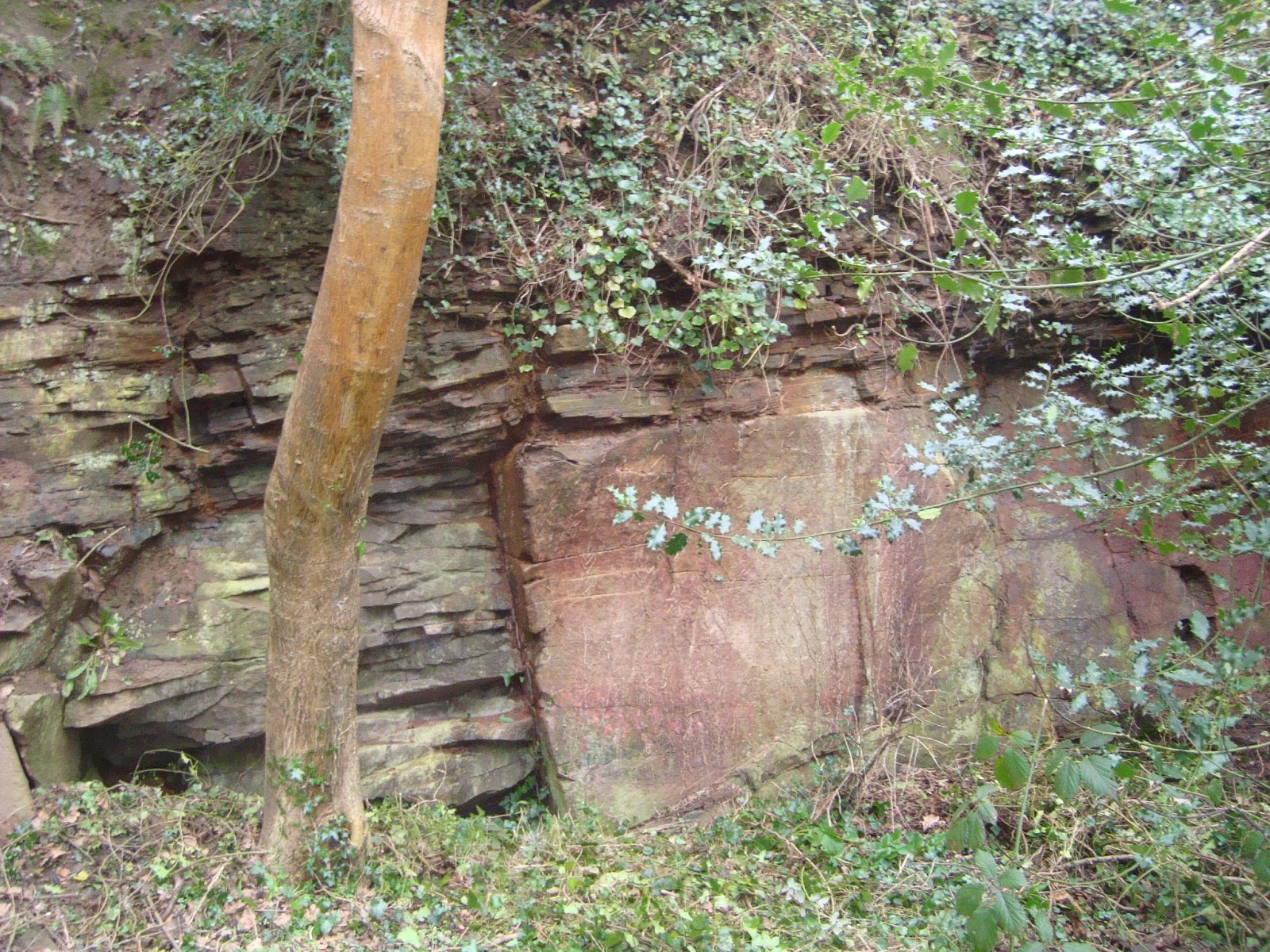
Pennant Sandstone
The sandstone at Troopers Hill is called Pennant, since the early geologists took the name traditionally used by miners and quarrymen. The Pennant forms a thick mass of sandstone in the middle of the local Coal Measures around Bristol, as well as in the Forest of Dean and South Wales. The name is thought to have been derived from the Welsh words penn and nant, meaning head of the valley.The rock is well exposed in the Gully Quarry, just south of Trooper's Hill chimney.
The sandstones exposed on the north side of the Gully display cross bedding, indicating that the original sand grains were carried by running water in rivers.
On the south of the Gully the rocks are coarser grained with coal pebbles and fossil imprints of tree trunks, suggesting that at times the water was flowing fast enough to erode sediment and move large pieces of wood.
 |
| Fossilised wood in Pennant Sandstone. Photo credit: Steve England |
Pennant was quarried at many sites in the local coalfields and provided stone for thousands of
buildings, including the chimney at the top of Trooper's Hill. It sometimes splits into thin slabs which
were much used for paving, kerbs, steps, gravestones, and, in earlier times, for roofing.
Mudstone
The mudstones were known as duns by the miners. They are less well exposed but can be seen in the paths to the south of Troopers Hill, and they indicate a period when the waters in the swamps must have been still. They had no commercial value.
Coal
The miners called the coal seams “veins” and gave them names which were used at each pit in the area where they were found, from Newton St Loe, near Bath, to St Phillips Marsh, in Bristol. Some seams thinned to nothing and others split, which made the naming uncertain in places. Each seam is thought to be the compressed remains of deposits of peat, built up from the remains of the trees of the forest.
Crewe's Hole Pit was sited at the south end of Troopers Hill, and is marked by the remains of he chimney of the mine engine house. Air Balloon Pit was next to Air Balloon Road, about half a mile north of the Hill. The mining geologist John Anstie was employed to gather information on all the local coal mines for the Royal Commission on Coal. He collected some details of what had been found in these pits, although both were disused when he visited the area in about 1870 and he was concerned that the information might not be completely reliable. He also observed that “the outcrops of the Devil's seam, Buff and Parrot seams, follow parallel lines about 500 yards to the north of those of the Millgrit and Rag seams ... (and at) ..Trooper's Hill .. the shallow works on all of them are clearly traceable.” He noted that the Air Balloon Pit only worked for three or four years as the seams were too variable to be worked economically.
Tom Fry was brought up near Troopers Hill and knew the area very well. He recalled one seam 5-6ft. thick revealed on the west side of the hill in 1968 before the council used the area as a rubbish tip. Tom recalled that in around 1910, his father used to warn him of the dangers of the hill, telling him that it was all undermined. His father worked in the Fireclay Mine. Tom also recalled the collapse of an old sloping shaft in the floor of the main quarry, the sides of which had been walled with mortared stone, and that he could trace the sites of at least six shallow mines on the Hill.
The mudstones were known as duns by the miners. They are less well exposed but can be seen in the paths to the south of Troopers Hill, and they indicate a period when the waters in the swamps must have been still. They had no commercial value.
Coal
The miners called the coal seams “veins” and gave them names which were used at each pit in the area where they were found, from Newton St Loe, near Bath, to St Phillips Marsh, in Bristol. Some seams thinned to nothing and others split, which made the naming uncertain in places. Each seam is thought to be the compressed remains of deposits of peat, built up from the remains of the trees of the forest.
Crewe's Hole Pit was sited at the south end of Troopers Hill, and is marked by the remains of he chimney of the mine engine house. Air Balloon Pit was next to Air Balloon Road, about half a mile north of the Hill. The mining geologist John Anstie was employed to gather information on all the local coal mines for the Royal Commission on Coal. He collected some details of what had been found in these pits, although both were disused when he visited the area in about 1870 and he was concerned that the information might not be completely reliable. He also observed that “the outcrops of the Devil's seam, Buff and Parrot seams, follow parallel lines about 500 yards to the north of those of the Millgrit and Rag seams ... (and at) ..Trooper's Hill .. the shallow works on all of them are clearly traceable.” He noted that the Air Balloon Pit only worked for three or four years as the seams were too variable to be worked economically.
 |
| The engine house in Troopers Hill Rd, c. 1914. Reproduced by kind permission of the Bristol Reference Library. |
Tom Fry was brought up near Troopers Hill and knew the area very well. He recalled one seam 5-6ft. thick revealed on the west side of the hill in 1968 before the council used the area as a rubbish tip. Tom recalled that in around 1910, his father used to warn him of the dangers of the hill, telling him that it was all undermined. His father worked in the Fireclay Mine. Tom also recalled the collapse of an old sloping shaft in the floor of the main quarry, the sides of which had been walled with mortared stone, and that he could trace the sites of at least six shallow mines on the Hill.
Fireclay
Fireclay is usually found beneath a coal seam and is basically the clay soil where the trees grew
which provided the peat deposits. Fireclay is rich in clay minerals which means that when fired into
bricks or tiles, they can withstand high heat. Tom Fry noted that the Troopers Hill fireclay was used
to produce high quality terra cotta tiles that were used in many local buildings.
Three fireclay beds are known to have been worked beneath Trooper's Hill.

Andrew Mathieson
Further reading

Downloadable leaflets on the geology, wildlife and history of Troopers Hill are available at http://www.troopers-hill.org.uk/leaflets/index.htm
December 2016 Update.
Eileen Stonebridge and Andrew Mathieson, of The Avon RIGS Group, have been working for some time with The Friends of Troopers Hill on the interpretation boards in general and the Geological interpretation board in particular. This new board can be seen near the Upper Chimney.
The four boards can be seen on this page of the Troopers Hill web site:-
References
Anstie, 1873, The Coalfields of Gloucestershire and Somersetshire, London
Bristol Fireclay Company Co Ltd, 1911, Section of the Mines at Troopers Hill
British Geological Survey 6 inch map Sheet ST 67 SW
Buckland and Conybeare, 1824, Transactions of the Geological Society of London (available online
through Google Books)
Cornwell, 2003, The Bristol Coalfield, Landmark Publishing
Fry, Accounts of my Earliest Years (up to 1922) www.troopers-hill.org.uk/memories
Kellaway and Welch, 1993, Geology of the Bristol District, HMSO
Prestwich, 1871, Report of the Royal Commission on Coal (in) Gloucestershire and Somersetshire,
HMSO (available online through Google Books)
The original walk was funded by our Stepping Forward Sustainability Grant, through the BIG Lottery Community
Spaces Programme www.troopers-hill.org.uk/steppingforward


