t
The Group's aim is to identify, survey, protect and promote geological and geomorphological sites in the former County of Avon - the modern unitary authorities of Bath and North East Somerset, Bristol, North Somerset and South Gloucestershire. RIGS are selected for their educational, research, historical and aesthetic value.

Friday 28 September 2012

The Geology Collection University of Bristol goes OnLine


The School of Earth Sciences at the University of Bristol holds a collection of over 100,000 mineralogical, paleaontological and petrological specimens which were donated to the School over the past 100 years. Some iconic specimens are an original map by William Smith, a near complete and mounted skeleton of a sabre-toothed cat, fossilised bones of early dinosaurs and an array of minerals from now inaccessible mines in the UK. The collection also contains over 1500 type fossils and published specimens, a unique and valuable resource to researchers worldwide.

Rhodochrosite from Argentina (BRSUG B2502)
 
Over the past decade efforts have been made to record and document the collection to unlock its scientific and educational potential. The current digitisation project OnLine aims to improve remote access to the wealth of geological specimens in the collection. The project includes the design of a brand new website as well as the development of an extensive photo archive and a searchable online database.

A taster of the future website of the Geology Collection University of Bristol, going live in autumn 2012.


Claudia Hildebrandt, Collections Manager: "With the valuable help of students and volunteers we have now digitise over 60,000 specimen records for online publication. We collected details from registers, card catalogues, collectors’ field notebooks and the specimens themselves and merged all information into a comprehensive database. Additional funding from JISC (as part of the BRICOLAGE project) allowed us to employ a student who reorganised taxonomic, stratigraphic and geographic entries and ensured consistency across the whole database.”

“We have also started to add recently taken photographs of specimens to the database. This will offer users a look behind the scenes of our stores.”

Volunteer Charlie Navarro editing photographs of Cretaceous chalk fossils.


Once the website goes live in autumn 2012 the OnLine project will enter its second phase.

Claudia: “We aim to create links between specimens and relevant scientific publications and publish a tool that visualises the geographic distribution of all our UK specimens. We will also add a feedback function to the catalogue which will allow amateurs and specialists to comment on specimens and send enquiries.”

"And this is just the beginning. Parts of the collection need to be revisited to update taxonomic and stratigraphic information. We also plan to highlight the historic value of our collection. Many honorable and well know geologists donated their samples to the Geology Collection, from local fossil collectors to internationally known palaeontologist. We would like to dig deeper and reveal the people behind our collection and the extraordinary journeys some of our specimens have been on.”

If you would like to find out more about the Geology Collection follow us on Facebook.

Claudia Hildebrandt

Friday 21 September 2012

Gryphaea arcuata


Fossils from the Avon RIGS area.
Gryphaea arcuata

Please read the geologist's code here:-  


Name                     Gryphaea arcuata
Phylum                      Mollusca
Class                      Bivalvia
Order                     Pterioidea
Family                    Gryphaeidae
Genus                     Gryphaea
Species                  G. arcuata


Gryphaea arcuata showing 'toenail' and ‘lid’.

Photo credit – Richard Kefford

Other, larger, pictures of this fossil can be found here


Source rock     Lias Group

Age range             Triassic/Jurassic,  Rhaetian 203 Ma – Aalenian 171 Ma

Locations              Several outcrops in area. The one pictured above was found at Hock Cliff in the Sinemurian strata of the Lower Jurassic from about 194 Ma.    SO 722 094

Please note that there are additional risks at this site which include:- unstable cliffs, difficult rocky and muddy foreshore, fast flowing currents and tides which can reach parts of the cliff. 
Check tide times before venturing onto foreshore.
Please see comment below from Andrew Mathieson.


Description of fossil

Gryphaea arcuata is an extinct species of foam oyster, a bivalve mollusc 
in the family Gryphaeidae. Commonly known as Devil’s Toenails.

Their temporal range is from late Triassic to early Cretaceous but their fossils are most commonly found in Jurassic strata.

These oysters lived on the sea bed in shallow waters, possibly in large colonies. The complete fossils consist of two articulated valves; a larger gnarly-shaped shell ( the “toenail” ) and a smaller, flattened shell, the “lid”. The soft parts of the animal occupied the cavity between the two shells, just like modern oysters. The shells also feature prominent growth bands. The larger, curved shell sat within the mud on the sea floor. These shells are sometimes found in fossil plates along with Turritella, Pentacrinites, Plagiostoma, clams, and sometimes shark’s teeth and fossilized fish scales.

Description of source rock in area – Lias Group.

                   Paleoenvironment
Nearing the end of the Triassic, the landmasses remain united, in the form of the supercontinent Pangea. The Tethys Ocean is actively spreading. The British Isles are at about 300 North.
        During the early Jurassic, Pangea breaks up resulting in Gondwana and Laurasia separating as the South Atlantic starts to rift open. The British Isles continue to drift Northwards to about 400 North. Lithospheric extension and passive rifting occurs to the East, starting to form the North Sea and to the West where the North Atlantic will later open.
        During the early Jurassic, sea levels continue to rise across the British Isles so Triassic desert sediments are replaced by a cyclic succession of fossiliferous dark grey marine mudstones, marls and limestones.

                   Lithology
        Predominantly grey, well bedded, marine calcareous mudstone and silty mudstone; thin tabular or nodular beds of argillaceous limestone, particularly in the lower part; thicker units of siltstone and sandstone, particularly in the upper part, and ironstone, particularly in the middle part. Marginal limestone facies also occur.

Richard Kefford


                  References

             - British geological Survey – Lexicon of rock units


Friday 14 September 2012


RIGS of the Month [September ] – Redcliffe Caves, Bristol


RIGS of the Month – September 2012.
Recliffe Caves – Bristol


Entrance to caves on Phoenix Wharf.

There are more pictures here.

Location: Phoenix Wharf, near Redcliffe Parade ST 589 723

This area has been a designated RIGS since 1986.

Access: The caves are owned by Bristol Council but access is controlled by the Axbridge Caving Group, who open the caves for tours annually during the Bristol Open Doors Day each September. They can also be approached for Group tours at other times, see here for details:


Risks: Low roofs, rough ground. Hard hats, stout footwear and torches advised. 

Friends Burial Ground showing cliff near hermitage.

The caves are not natural caves but excavated tunnels into the Redcliffe Sandstone. They were originally excavated to provide sand for glass making and have been used over the years for many different storage purposes.
The foundations of what is now the Mercure Hotel can be seen underground, in the caves.
The sandstone underground is massive with little jointing and no cross- bedding can seen although examples can be seen in this formation at the exposure in the Friends Burial Ground adjacent to the hermitage entrance.

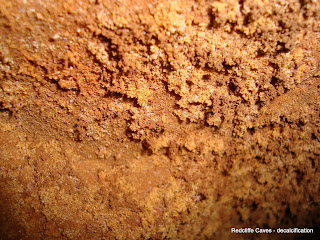
Efflorescence from roof surface

There is surface efflorescence in several areas from the roof, which is assumed to be the decalcification referred to in the Bristol memoir.
The headroom varies around a norm of 2m and there is estimated to be some 6m of sandstone between the cave roof and the ground surface above.
The floor is mostly composed of dumped ash and slag – from the old lead works – that have consolidated over time.
Tree roots have penetrated in some areas.

Cross bedding near hermitage

The caves are cut into the Triassic Redcliffe Sandstone Member.

Redcliffe Sandstone Member ( RESA )

Lithological description:
Sandstone, distinctive fine to medium grained, deep red, calcareous and ferruginous. Commonly decalcified at shallow depths below the surface, giving rise to an uncemented sand.

BGS Computer code:
RESA

Definition of Lower Boundary:
Unconformable, at the abrupt base of the red sandstones of the Redcliffe Sandstone Member overlying sandstones and mudstones of Late Carboniferous age. 

Definition of Upper Boundary:
Conformable and gradational, with interdigitation between red sandstone of the Redcliffe Sandstone and reddish-brown mudstone of the Sidmouth Mudstone Formation (undivided).

Thickness:
Up to 65m

Geographical limits:
Crops out in the Bristol area between Bedminster and Winterbourne.

Parent Unit:
Sidmouth Mudstone Formation

Group:
Mercia Mudstone Group

Age:
Triassic

Stratigraphic setting:
Following the Variscan orogeny at the end of the Carboniferous Period, erosion stripped off some of the Coal Measures during the Permian so the RESA was laid down unconformably on the irregular remnant Carboniferous landscape, diachronous with the marginal facies of the Mercia Mudstone Group. RESA was deposited in an elongate depression between Bedminster and Winterbourne and locally exceeds 50m in thickness. The RESA passes laterally into red mudstones and is locally interdigitated with Mercias Mudstone Marginal Facies ( MMMF ). The best exposures of RESA are found in cliffs along the Avon in Redcliffe, the eponymous district of Bristol, and in the New Cut along Coronation Road, Southville.

Applied geology:
RESA was used for glassmaking, the glass being used to make bottles for the thermal water from the five Bristol hot springs which were then largely exported.
The RESA is an aquifer which was an important source of water for Bristol in the past until contamination from local cess pits and burial grounds resulted in several epidemics.

Ground conditions:
In some areas the RESA has become decalcified, losing its cement and becoming friable and difficult to handle when wet. Changes in groundwater regimes can be responsible for this decalcification process, which in turn can cause local subsidence. Weathered RESA , when used for fill material has also been known to provide poor support for buildings.

References:
BGS Lexicon           -           http://www.bgs.ac.uk/lexicon/
BGS map      2004   -           England and Wales sheet 264 – Bristol – Solid and Drift
BGS Memoir 2002   -           Geology of the Bristol District
Memoir 1949 / 2000 -           Geology & scenery of the West of England – AE Turner & N Chidlaw                         
Cave web site         -            http://www.bristoltours.com/Redcliffe.htm
Photo credits          -            Richard Kefford

Richard Kefford

Friday 7 September 2012

Nailsea Environmental & Archaeological Team – NEAT

Nailsea Environmental & Archaeological Team


NEAT - Aims and Objectives

Nailsea Environmental & Archaeological Team – NEAT, was set up in September 2004 to undertake archaeological research in the Nailsea area, including Tickenham, Wraxall, Backwell, Chelvey and Brockley.
     Our aim is to carry out fieldwork to find new archaeological sites, record existing sites and to augment the North Somerset Historical Environment Record, in conjunction with the County Archaeologist. 

     The methods used include land survey, geophysical survey, map regression and reference to local archives and involve work with other similar groups in North Somerset. 

     In addition, NEAT has carried out a survey of dry stone walls in Nailsea, recorded the age of buildings and recorded the hedges in the area. There is research ongoing into other aspects of our local environment. 

     During 2011 NEAT established a geology group with the initial aim of establishing ‘geotrails’ around the area to show and explain the local geology. It is intended to complete the geotrails project and publish a guidebook in 2012.

     There is a live link to the NEAT web site in the right hand column on this blog home page.

David Sowdon