t
The Group's aim is to identify, survey, protect and promote geological and geomorphological sites in the former County of Avon - the modern unitary authorities of Bath and North East Somerset, Bristol, North Somerset and South Gloucestershire. RIGS are selected for their educational, research, historical and aesthetic value.

Showing posts with label Geoconservation. Show all posts

Tuesday, 5 February 2013

Geo-gardening at Trendlewood Quarry, Nailsea


Geo-gardening - Sunday 3rd February 2013

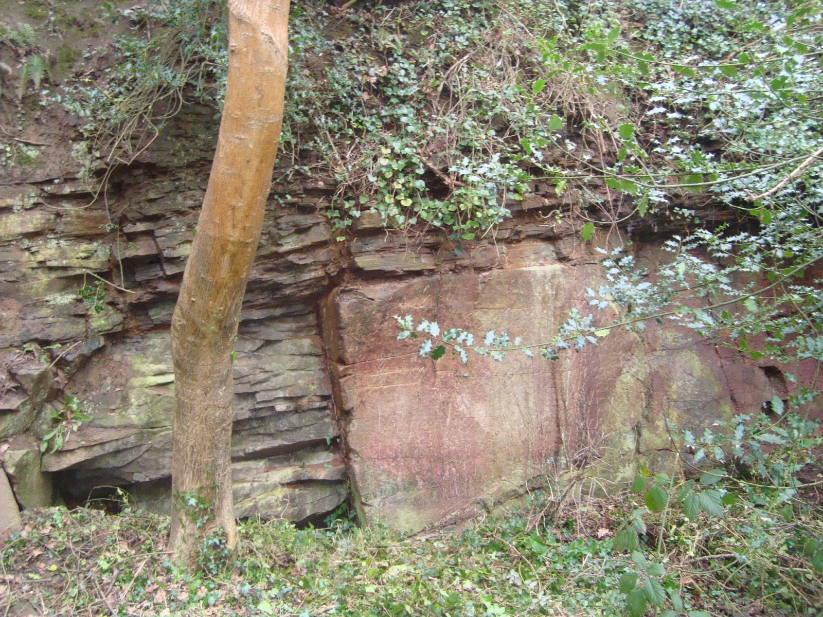
On Sunday 3rd February 2013 a Joint Gardening Force (JGF) from Friends of Trendlewood Park (FoTP) and Avon RIGS Group descended on Trendlewood Quarry in Nailsea and proceeded to spend a few hours clearing ivy and other encroaching vegetation from the lower parts of the quarry face in three areas.

Before worked started. Photo credits: Richard Kefford. More photos at
These three areas were selected to demonstrate the differing bedding types – from varves to massive -  in this Pennant Sandstone of the Downend Formation and the differing types of deposition – point bars and channel deposits.


Geo-gardeners at work

This is the first part of the implementation of the quarry management plan that was agreed at a site meeting between N Somerset Council, Friends of Trendlewood Park and Avon RIGS Group. The second part which will be carried out by the N Somerset Green Team will consist of clearing the upper levels of the face and removing a few selected trees that are in danger of falling and have extended their roots into the joints and fissures rock close to the face and so are damaging the exposure.


Meeting one of the site natives


See here for details of the geology of this site and its location.

A cleared area on one face
Richard Kefford


Monday, 4 February 2013

Earth Heritage magazine

Earth Heritage magazine - free download

Earth Heritage is a magazine produced twice yearly to stimulate interest in geodiversity and a broad range of geological and landscape conservation issues within the UK and further afield. It is produced by Natural England, Scottish Natural Heritage, Countryside Council for Wales and the Geologists' Association. 
 
 
You can download the latest issue for free here

Friday, 3 August 2012

Habitat and RIGS management - with Justin Smith


Justin Smith is the Woodland & Wildlife Officer for Bristol City Council and is also the Vice Chair of the Avon RIGS Group. We talk to him about his work in habitat management and how this involves RIGS.

Hi Justin. Can you tell us about your background and how you got into the role of Woodland & Wildlife Officer?
From a young age I had a passion for natural history and went on to study geology at Exeter. After graduating, I started off working in environmental consulting, before moving into the voluntary sector, undertaking wildlife conservation and learning about the natural world. I subsequently took on a role with Avon Wildlife Trust, which lead to me becoming the council's Woodland & Wildlife Officer three years ago. I also undertake some freelance ecological consulting, specialising in fungi, lichen and bryophyte (mosses and liverworts) surveying.

What does your job involve on a day-to-day basis?

The work that comes with the role varies tremendously by season. The majority of scrub clearance and woodland work is carried out in the winter months for a variety of reasons: trees and scrub are essentially dormant after their leaves have fallen and so there is less stress, when cutting, on their growing systems; there is less inconvenience for park users; and we avoid disturbing nesting birds. In the summer I divide my time between planning for the next winter and carrying out habitat surveys.

Does your work involve volunteers or community groups?
Much of the labour that comes with habitat management is done by a not-for-profit organisation called Blue Skies. They coordinate and employ ex-offenders and people on community payback to carry out ground maintenance work. Not only is this a cost effective arrangement for the council, it also gives the people involved a chance to pick up new skills and take an interest in their local environment. In successful cases, this can lead to people obtaining placements at other organisations, and offers a chance to break the cycle of repeat offending.
Scrub clearance in action

Can you give an example of a nature conservation success story that you were involved in?
A site that springs to mind is Hawkfield Meadow in south Bristol. This was an area of species-rich meadow that was neglected for 15 years and was under constant threat of development. In the 1990s, some of the land was built on and the small section of meadow that remained was gradually scrubbing over, thus decreasing its nature conservation value. There was a very real risk the site would be lost altogether. In 2010, the newly created Woodland & Wildlife team came in and cleared a substantial amount of bramble and scrub, put in footpaths and took measures to ensure the site could return to meadow. There is a still lot more to do in terms of public access, but the team has recently ensured that the meadow is cut once a year to maintain as hay meadow; this should encourage less competitive, and often rarer, species to colonise and spread more successfully.

Species rich hay meadows have a rich diversity of flora and provide important habitats for ground nesting birds and butterflies. This photo is taken in Ravenstonedale in Cumbria. Photo credit: http://www.lancs.ac.uk

How does geology, and more specifically RIGS, come in to your work?
RIGS exposures are commonly found as cuttings next to paths in woodland areas and can often become overgrown. A heavy prune of a small section can be as little as half a day's work, and often may not need to be done again for 3-5 years. Clearing vegetation from outcrop faces can also be used to increase the amount of exposure to increase a site’s educational value.

Fir Woods RIGS, Clevedon, before and after management. Once cleared of ivy, the outcrop revealed an unconformity between Carboniferous Limestone and Triassic Dolomitic Conglomerate The Avon RIGS Group is working with North Somerset Council to establish regular clearance as part of a management plan for RIGS sites.

Are there ever conflicts of interest within the scope of habitat management?
This is something that is close to my heart given my interest in lichens and fungi! All wildlife rich sites have to balance the needs of their various components, and not all conservation measures are necessarily beneficial for every aspect of a site. If a RIGS is covered in an exceptionally rare moss, how do we determine which is more important? The exposure of an important geological formation or the preservation of the plant? Luckily this particular example is not a common occurrence because, in reality, brambles and ivy do the most damage to rock units.

And finally, what is your favourite Avon RIGS?
It has to be the road cutting on the Clifton side of the Clifton Suspension Bridge on Bridge Road.  Here, the Clifton Down Limestone is exposed and contains Lithostrotion corals, calcite veining and a small number of quartz geodes. There is also botanical interest with a wild plant display of the rare flora (such as Autumn Squill) that thrives in the Avon Gorge.

Charly Stamper

Friday, 6 July 2012

Avon Wildlife Trust

In the first of a new series, we catch up with local groups who are involved in geoconservation in the Avon region. First up, Avon Wildlife Trust.


From belemnites & brachiopods to bats & bullfinches...

Avon Wildlife Trust is committed to working for people and wildlife in the local area, and we manage 35 nature reserves, some of which are also sites with outstanding geological features. One reserve which has been at the centre of our recent 'Bats for Bath' project is Brown's Folly.

Brown's Folly, Bathford. Photo credit: Avon WT
Browns Folly Nature Reserve is a Special Area of Conservation (SAC) and Site of Special Scientific Interest (SSSI) that has rare calcareous grassland habitats, unique geology, ancient woodland and a cave system with fantastic bat populations, with 12 of Britain’s 18 Bat species having been recorded here.  The caves are the remnants from mining the local oolitic limestone which was extracted for building material, and which is known locally as 'Bath Stone'. Oolitic limestone gets its name from the spherical particles or 'ooids' it contains. This word comes  from the Greek word for 'egg' because ooids are thought to resemble fish eggs. You can see fossils  in the exposed stone - thick shelled bivalves such as Trigonia, found today in the Pacific, along with brachiopods, ammonites and belemnites which once swam in the sea which covered this area 170 million years ago.

Oolitic limestone hand specimen (left) and thin section (right). Photo credit: http://www.earthscienceeducation.com

The stone was used for building in Roman times, but intensive mining of the limestone beds in the valley was carried  out from the 17th to the early 20th century. The characteristic stone was used for the construction of most of Bath's famous buildings, as well as Buckingham Palace and many stately homes across the country. The different mines, which were driven in to the rock in the  area, stretched for many miles and contained stables, cart-roads and tramways. Stone was extracted by the 'room and pillar' method, by which chambers were mined, leaving pillars of stone to support the roof.  By the time the mines closed down in 1930 there were over 300 acres of interconnecting underground workings and tunnels, which were used for storing ammunition and government  records during the Second World War.

Bats are very fussy about their roosting sites - they need somewhere with stable temperature and ventilation levels, and the old mine tunnels under the woodland seem to suit them very well. The huge size of the mines means that areas deep down are less affected by outside variations in climate - a perfect spot to hibernate for the winter months. The Trust has installed bat grilles on the entrances of the mines in the woodland to make sure that the bats remain at peace within their hilly homes. Bats are protected by law, and the grilles also prevent access to the mines - protection for people as well as preserving peace for the bats. In spring and summer when the bats awake and come out to feed at dusk, the grassland glades of the reserve are rich with insects right on their doorstep.

Greater horseshoe bat - just one of the twelve species recorded in the caves at Brown's Folly. Photo credit: Avon WT
Brown's Folly in Bathford is one of our most popular reserves that receives around 5000 visitors each year with most people enjoying the fantastic views from the grassland plateau across to Bath and the surrounding area, and talking long walks through the ancient woodland full of rocky fissures, giant veteran trees, mosses and ferns, and open glades that all help support the bats roosting in the caves.

You can read more about Brown's Folly and other Trust nature reserves here.

Pat Ellingham
(Avon WT Director of Communications and Development)


Look out for more information on the geology of Brown's Folly - it is soon set  to feature on the blog as a RIGS of the Month.

Friday, 9 March 2012

An interview with...


 David Villis has been the South Gloucestershire Ecologist since 2001 and sits on the Avon RIGS committee. I asked him to tell me a little bit about himself and his involvement in geoconservation in the Avon region.

Hi David. I wonder if you could briefly explain what being the South Gloucestershire Ecologist involves on a day-to-day basis?

I am part of the Strategic Planning Policy and Specialist Advice Team for South Gloucestershire Council. I work with landscape officers, archaeologists and conservation officers and, whilst there to give advice to other Council departments and the public, my primary role is to provide comments to the Development Control and Major Sites teams on planning applications. These range from to new power stations to house extensions.

How did you come to be in your current job?

In terms of academic background, I studied Applied Biology at Hatfield Polytechnic. Immediately after I graduated I managed a record shop for four years, which was great fun!  I started work with the Nature Conservancy Council (subsequently English Nature and Natural England) in the 80s and in 1991 took up the position of Protected Species Officer, working predominantly with bats, badgers, great-crested newts and dormice. It was through this role that I gained an insight into the planning process and that led me to applying for my current job. 

A hibernating dormouse.  Protected Species Officers look after the interests of dormice and similarly legally protected species in the UK. Photo credit: John Robinson/Natural England.

Considering your biological background and ecological job title, how does geology fit into your role?
When a planning application comes in, the first thing we do is locate the proposed development on our GIS database. If an area has previously been recorded as having geological importance, such as a SSSI or RIGS, this will be flagged up and taken into account throughout the application. A lot of planning proposals have low geological impact; landfill and quarry expansions/restorations are generally the most significant issue that we have to consider with regard to RIGS.

You mentioned RIGS and SSSIs – what exactly is the difference between the two?
They are part of the hierarchy of how natural heritage, specifically geology, is defined and preserved. At one end of the scale you have outcrops that are internationally important and are UNESCO World Heritage Sites, such as the Jurassic Coast. Geological SSSIs (Sites of Special Scientific Interest) are considered to be nationally important and can comprise either exposures or deposits; a good local example is Burrington Coombe in the Mendips. The next step down from SSSIs are Local Sites. RIGS (Regionally Important Geological and geomorphological Sites) fall under this umbrella. They represent outcrops that have regionally significant scientific and educational value. 
 
In terms of legal protection, what does the designation of a RIGS actually mean for an outcrop?
A RIGS is a non-statutory designation.  This means that the site doesn’t have any legal standing but is protected from development under the South Gloucestershire Local Plan. Policy L8 of the Plan does not permit development that would cause damage to a RIGS unless the importance of the development is considered to outweigh the value of the affected RIGS, in which case measures will be taken to minimise and offset the impact on the outcrop. As a local authority, we have no influence over the management of RIGS although we of course encourage all landowners to manage them sympathetically.

How does a site in the Avon region become a RIGS?
Technically outcrops can be put forward for designation by anybody, although in reality nearly all are proposed by the Avon RIGS Group. Members of the RIGS Group evaluate any putative site against the criteria for designation and then present it to the Local Sites Partnership (of which the Avon RIGS Group are a member body) for official approval. Their recommendation is then taken by myself and presented to the Executive Member for the Environment for South Gloucestershire Council and, if approved, the information is sent to BRERC (Bristol Regional Environmental Records Centre) for digitisation and inclusion on the GIS database.

Have you been involved in any cases where the geology has significantly impacted on a planning proposal?
A recent success story for RIGS has been Barnhill Quarry in Chipping Sodbury. The quarry was operational from the late 19th century until the mid-1960s with the Carboniferous limestone being exploited for aggregates and building stone. Extraction of the rock led to the revealing of some magnificent exposures in the quarry walls, including stromatolites, limestone pavement, ripple bedding, dolomitic wadi deposits, thrust planes and an well-defined unconformity between Triassic shales and Carboniferous limestone. Part of the site was assigned SSSI status in 1966, with subsequent audits awarding RIGS designation to the whole quarry.

Exposures at Barnhill Quarry, Chipping Sodbury. Left: Fossil stromatolites in Carboniferous Limestone. Right: Ripple bedding in Lower Cromhall Sandstone. Photo credit: WYG Environment, Barnhill Quarry Geoconservation Assessment

In 2010, we received a planning application to partially infill the quarry and build 170 house plus a large supermarket. Obviously the potential development posed a significant threat to the geology and we had to ensure any construction activities did not destroy important aspects of the site. For example, if any exposures would be covered by the infill, we needed to be satisfied that the characteristics were replicated elsewhere in the quarry wall.

In terms of implementing changes to the planning application, our approach was threefold. Firstly, we made provisions for surveying the site before and during construction activities. Secondly, we incorporated educational features into the proposed development such as an information hut, interpretation boards and a geo-trail, as well as improving public access, which is currently forbidden. Finally, it is essential the outcrops are monitored and maintained, for example keeping rock faces clear of vegetation.

All this is tied into a Section 106 agreement; this means that if the proposal goes ahead, the cost of the conservation measures is met by the developers.

What is your favourite RIGS?
My favourite local geological outcrop is Aust Cliff, a cliff exposure about 10km north of Avonmouth on the Bristol Channel. Not only does it have national significance with great exposure of the Westbury Bone Bed, the colourful strata are visually dramatic. It really is a spectacular sight when driving across the Severn Bridge in the late afternoon with the bedding planes in the rock face highlighted in the low-lying sun. The site accessibility is superb and it’s a perfect outcrop for educational and recreational visits. 

Aust Cliff SSSI, north of Avonmouth, is one of the best exposures in the country of uppermost Triassic and Lower Jurassic rocks. The colourful strata document the transgression of the Jurassic sea over Triassic desert plains. Photo credit: David Villis

Charly Stamper