Friday, 31 August 2012

Inspiring the next generation

Kate Hibbert, University of Bristol
Guest blogger Kate Hibbert is a PhD student in Earth Sciences at the University of Bristol. She is also a STEM ambassador and is interested in how academics can inspire the next generation of scientists.
 
Postgraduate students at the University of Bristol are heavily involved with outreach teaching activities, visiting Bristol schools to talk about various topics in Earth Sciences. Volunteers are co-ordinated by the STEM ambassador scheme. The aim of the scheme is to get more young people involved with STEM subjects (Science, Technology, Engineering and Maths) and it effectively acts as a matchmaker between schools and willing expert volunteers. The network includes professionals as well as university students. STEM ambassadors go in to schools and might, for example, run a workshop, provide mentoring for a small group, talk to an after school club or take part in a careers fair.

Bristol students have been involved in several projects, including the Bristol Dinosaur Project. Thousands of school children of all ages have had a visit from the Dinosaur Project team, giving them the opportunity to learn about this dinosaur unique to the Bristol region in an interactive workshop. The session also involves a life-sized jigsaw of the Bristol dinosaur and handling real fossil specimens, an activity that never fails to spark the imagination.

Primary school children getting some hands-on experience of life as a palaeontologist. Photo credit: Bristol Dinosaur Project

But it’s not just dinosaurs that can inspire children – workshops run by Bristol Earth Sciences PhD students have covered a wide range of topics, from the rock cycle to volcanoes to meteorites. A workshop might involve handling rock specimens, squashing plasticine to learn how a metamorphic rock is made, or using the classroom to reconstruct the scale of the solar system.

Teaching the rock cycle using crayons. Photo credit: http://mesmrswhitesclass.blogspot.co.uk

The benefits of these school visits are not limited to imparting knowledge about the topic covered, but also come from allowing children to meet ‘real-life scientists’, helping to break down some of the stuffy scientific stereotypes and encourage more people into science subjects and science careers. The rewards for volunteers are great, not least giving confidence in public speaking. If you can successfully hold the attention of a classroom of 10 year-olds, then giving a professional presentation seems significantly less daunting! 
Three lots of fossil finds for local school children. Photo credit: Bristol Dinosaur Project

Kate Hibbert

Links:

If you’re interested in the STEM ambassador scheme or want to arrange for an ambassador to visit your school: http://www.stemnet.org.uk/content/stem-ambassadors

A previous blog post about the Bristol Dinosaur: http://avonrigsoutcrop.blogspot.co.uk/2012/02/bristol-dinosaur-project.html

Friday, 24 August 2012


The William Smith Stone Column


The William Smith Stone Column near Wellow

Photo credit Andrew Mathieson

In 2006 the transport charity Sustrans commissioned the sculptor Jerry Ortmans to design and construct an art installation to celebrate the work of William Smith, the “Father of English Geology”. This Stone Column was to be in natural stone and to be installed near the village of Wellow, a few miles south of Bath, and along Route 24 of the National Cycle Network. The section of the Route from Bath to Frome has been called the Colliers Way and it provides new access to both the disused Somerset and Dorset railway line and the original route of the southern branch of the Somersetshire Coal Canal, which Smith worked on between 1793 and 1799.

        The siting was intended to link Smith's understanding of the local geology with his work on the survey and construction of the canal, which gave him so much evidence for his ground breaking understanding of stratigraphy and the use of fossils to identify beds of rock. In fact, although most of this southern branch of the canal was excavated, the company ran out of funds to build a flight of locks and it was never connected to the rest of the canal by water. Instead coal was carried along the original towpath on a horse-drawn railway and transferred to boats on the main canal near Midford.

        The design of the sculpture was based on Smith's account of the sequence of local rocks which he drew up in his famous Table of Strata in 1799, shortly after his dismissal from the Coal Canal Company. Seven large blocks of local rock were chosen and these were arranged into a vertical structure in their order of succession. Ortmans worked with local geologist Simon Carpenter to select suitable stone from a number of working quarries in the West of England, and they range from Carboniferous Pennant Sandstone up to Cretaceous Chalk.

        Sustrans also commissioned two information panels to be installed along the Colliers Way to help visitors better understand Smith's work in terms of the local geology and his work on the construction of the Coal Canal. One was placed beside the Stone Column and it concentrates on the local geology and Smith's work and the history of the Canal. It features a little-seen engraving of Smith in 1807, when he was aged 38, and emphasizes that the canal was one of the most prosperous in the south of England. Unfortunately there is little evidence of the canal nearby since its route was mostly destroyed by the construction of the railway.

        The second information panel is just south of the Midford railway viaduct, and this mainly deals with the various forms of transport which once existed nearby. There is a photograph of a train on both the Somerset and Dorset and the Limpley Stoke – Camerton lines in 1958, when the latter railway was being scrapped. The illustration for the Coal Canal is a photograph of Midford Weigh House which was taken in about 1890. An extract from a geological map of Smith's is also included. This was published in 1820, several years after his famous geological map of England and Wales, and Smith included all the existing canals and railways of the time.

        Although these installations are a distance from the sites most people associate with William Smith (Tucking Mill, Rugborne House, etc.), they add new ways of commemorating his pioneering contribution to geology and in addition are set in an area of attractive Inferior Oolite and Fullers Earth countryside which Smith would have known well.

Andrew Mathieson

Friday, 17 August 2012

Box Rock Circus

Box Rock Circus

http://www.boxrockcircus.org.uk

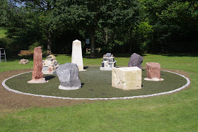
FIG 1: The Box Rock Circus. The standing stones, from left to right around the perimeter, are Permo-Triassic New Red Sandstone, Carboniferous Limestone, the Jurassic Box Bath Stone table, Devonian Old Red Sandstone and Silurian andesite. Photo credit Charles Hiscock
A larger version of this and all the other photos can be seen here

There is the old saying that ‘The sun shines on the righteous’ and this was particularly true on Thursday 9th August 2012 when the sun blazed down for one of the few days of Summer 2012 at the village of Box, near Corsham, Wiltshire. At 11am on that very warm morning, the good and great (and righteous!) of Box gathered at the village recreation ground for the unofficial unveiling of the ‘Box Rock Circus’, carried out by the Chairman of the Box Parish Council, Pauline Lyons, to mark completion of the construction with many villagers and children and representatives of the press in attendance.
‘Box Rock Circus’, the brainchild of well-known local geologist and Earth Science Educator, Elizabeth Devon, is a circular arrangement of large stone blocks and rock sculptures designed to tell the history of the rocks that we can see in our environment, enabling people to touch, examine, climb on and over or just admire the originality of thought that has produced this superb feature.

FIG 2: Elizabeth Devon, who had the original idea and designed the Box Rock Circus, stands beside the Bath Stone obelisk. Photo credit: Charles Hiscock 
The circular array contains 5 large blocks of rock donated from quarries in differing geological areas. The Carboniferous Limestone block, packed with fossil corals, came from Wickwar Quarry while the volcanic Silurian andesite originates from Moon’s Hill Quarry at Stoke St Michael on Mendip. Two large blocks of red sandstone represent the Devonian Old Red Sandstone, from Black Mountain Quarries of Herefordshire, and the Permo-Triassic New Red Sandstone from Capton Quarry near Williton, Somerset. Local rocks are used for the ‘table,’ cut from the Jurassic Hartham Stone, and the beautifully carved obelisk (fig. 2) from Jurassic Box Ground Bath Stone Quarry, the latter illustrating the importance of this fine rock in the history of Box. The quarry has supplied fine Bath Stone for 1000 years but was closed for 60 years until it was recently reopened. Inset in the top of the ‘table’ rock are moulds of a range of fossils (fig. 3) – Silurian trilobites, Jurassic ammonites, a Carboniferous dragonfly, the first Cretaceous bird Archaeopteryx, starfish, a fossil worm trail and a fish - that children (of all ages!) can reproduce in the same way as brass rubbings. Also on the table is the badge of the Geologists’ Association which sponsored the fossil rubbings through the Curry Fund. 
FIG 3: Inset in the top of the 'table' rock. Moulds of a range of fossils including Silurian trilobites, Jurassic ammonites, a Carboniferous dragonfly, the first Cretaceous bird Archaeopteryx, starfish, a fossil worm trail and a fish. Photo credit: Charles Hiscock 

The sculpted blocks are built up from specimens of different rocks and are intended to be climbed over by children as well as examined for their content of rock types. One is composed of sedimentary rocks and fossils sourced locally and from further afield, topped by a polished block of Purbeck Marble sitting on a specimen of fossil ripples (fig. 4).

FIG 4: The sedimentary rocks and fossils sculpture, topped by a block of Purbeck Marble. Photo credit: Charles Hiscock

The crystalline block contains specimens of igneous and metamorphic rocks, many as polished slabs as used for kitchen worktops and, completing the top, a sculpture of a tiny house built from slates, surrounded by pieces of lavas and a volcanic bomb (fig. 5).
FIG 5: The crystalline rock sculpture, including  slates, pieces of lavas and a volcanic bomb . Photo credit: Charles Hiscock

The rocks, obelisk and sculptured blocks are set in concrete, pinned with steel rods to the base and surrounded by a greenish rubbery matrix made from recycled tyres providing a soft play area for children. Made from the same material are two sets of dinosaur footprints, coloured black which cross the circular area (fig. 6). The outside perimeter is made from granite setts which will, in due course, be painted with red marks to show the geological timeline and how life only evolved very recently. In fig 01, the sculpted blocks stand either side of the obelisk, the sedimentary rocks and fossils on the left while the crystalline rocks stand on the right. The standing stones, from left to right around the perimeter, are Permo-Triassic New Red Sandstone, Carboniferous Limestone, the Jurassic Box Bath Stone table, Devonian Old Red Sandstone and Silurian andesite.
FIG 6: Dinosaur footprints across the Circus. Photo credit: Charles Hiscock

The project has received the backing of Box Parish Council and local organisations and been funded by a Landfill Communities Fund grant from the Hills Group Ltd. Construction of the Circus was carried out by a team of skilled craftsmen managed by stonemason Marcus Mitchell. The celebration on that sunny Thursday morning marked the completion of the construction work but there is more to be done such as the red ‘timeline’ to be painted, with one year representing the age of the earth and an interpretation board is to be set up. 

The website - http://www.boxrockcircus.org.uk is to be updated to give information about the rocks and fossils and fact sheets and a childrens’ quiz will be downloadable and also available in the village. 

Elizabeth Devon will be very happy to explain the Rock Circus and can be contacted on the Earth Learning website elizabeth@earthlearningidea.com. The official opening is to be held later in the year on a date yet to be agreed.

Charles Hiscock

Friday, 10 August 2012

RIGS of the Month [August] - Blaise Castle Estate


RIGS of the Month - August
Blaise Castle Estate

Geological Time Travel in a Land of Giants


A view for all seasons southwest over Henbury gorge from Castle Hill towards Failand Ridge on the horizon. 


Please follow the Geologist's Code.
http://www.brerc.org.uk/rigs_site/geologists_code.htm


SITE SPECIFIC INFORMATION
Location: Henbury, Bristol.
Accessibility: Various access points, see map. From Coombe Dingle car park, on metaled paths through steel gates. Maximum gradient 12%. Some points off main paths are steep and over rough ground. Contact duty ranger on 07795 445999 for car park opening times and gate access for wheelchair users.
Risks: Beware of cliff edges.
Topography: Steep-sided, incised plateau with shallow streams.

All photos from this post can be viewed in a larger format - http://tinyurl.com/blaise-rigs


Blaise Castle Estate is a magnificent Grade II listed parkland.  Jane Austen wrote in Northangar Abbey: “Kingsweston! Aye and Blaize Castle too…The finest place in England – worth going fifty miles at any time to see.”  Here though, Thorpe is somewhat deceitful in his persuasion of the reluctant Catherine to join the excursion from Bath. Even so, Blaise is justly renowned for its picturesque landscape, making it a popular attraction to this day.

18th Century Blaise Castle House and Museum.
Blaise is set mainly onto the Carboniferous Limestone ridge of Kings Weston Hill and Castle Hill, on the western outskirts of Bristol. This dramatic and scenic incised plateau area is a microcosm of the solid geology of the Bristol district. The changing environment and evolution of the landscape can be traced from its sedimentary rock units in the section dating from the late Devonian period, c 360 Ma. Tectonic forces and thrust faults that shaped the region are evident from the folded strata of the Westbury Anticline along with steeply-dipping, overturned and shattered beds in the northern limb of the anticline. Finally, a drainage system etched its channels through the covering sediments and into the Carboniferous rocks to form the spectacular, steep-sided, densely-wooded Henbury gorge: a recent sculpting of the landscape, also seen in similar features across the region, from the nearby Avon Gorge to Burrington Coombe  and Cheddar Gorge in the Mendip Hills.

The Blaise Castle Estate/Kings Weston Ridge RIGS extends from Henbury, ST 562 788 westward along the northern limb of the Westbury Anticline as far as Shirehampton, ST 530 774 and southwest to Coombe Dingle, ST 558 773 including the River Trym valley from Coombe Farm, ST 563 776 to Sea Mills Lane, ST 555 766.  The site is important for education and research into the palaeoenvironment of the region, periglacial landscapes and stream action.  Its rich variety of rock units along with their twisted and contorted structures make for a challenging lithology and stratigraphy.  It’s an area of extraordinary natural beauty, complex geological structure, with some remarkable exposures.

Click to switch map, change view and read bedrock descriptions. 

A walk through geological time starts in Coombe Dingle by the River Trym, see gorge walk, at the base of the succession in the late Devonian, c 360 Ma. From the confluence of the Trym and Hazel Brook the course of Hazel Brook is followed into the shady gorge and a gentle ascent to the top of the early Carboniferous, c 330 Ma and the giant’s footprints on Castle Hill.  From nearby Lover’s Leap, and then from the legendary giant Goram’s Chair opposite, the full panorama of Blaise and the gorge can be admired.

The massive and thick-bedded river cliffs of conglomerate at the Coombe Dingle entrance rest on the Upper Old Red Sandstone of the Portishead Formation.  These 10m high cliffs of Triassic age were formed c 206 to 248 Ma from the debris of shattered and scoured uplands in Carboniferous and Permian times.  Debris collecting in the valleys and wadis below were cemented into the Mercia Mudstone Marginal Facies (dolomitic conglomerate) along shorelines, wedged between and against the limbs of the Westbury Anticline, forming the present day bedrock. 

Outcrops of Triassic dolomitic conglomerate can be seen where the dry stream tributary meets the Trym at Stoke Bishop (above) and also by Hazel Brook near Henbury Church.

The angular unconformity where the Triassic breccia overlies what appear to be vertical beds of Devonian old red sandstone is exposed at ground level to the left of the path c 150m from the Coombe Dingle entrance. A similar unconformity, but with a conglomerate of different origin, is exposed on a far greater scale at Kilkenny Bay, Portishead. At Blaise, the Upper Old Red Sandstone continues along the wooded slopes beyond the Trym floodplain, on the south side of the Trym valley, heading east to Westbury-on-Trym. These rocks were formed by rivers depositing sand and gravels into river channels, c 354 to 364 Ma.

Angular unconformity where the Triassic dolomitic conglomerate overlies vertical beds of Devonian upper old red sandstone.


After a few metres along the path the base of the Avon Group is reached marking a change from fluvial and deltaic to marine environments, c 344 to 354 Ma. Down-slope to the river confluence outlines a small area for the Shirehampton Formation. Surface rock samples show light-grey, medium-grain, crinoidal limestone, possibly formed in a warm shallow sea or lagoons. Across the Hazel Brook weir footbridge and close to the river bank marks the boundary with a thin bed above the Shirehampton Formation. Rock samples show a distinct reddening of finer grained, sparsely fossiliferous limestone and red-brown, siltstone that together may reveal the Bryozoa Bed.

From the main path above the footbridge, an unmade path forks left and leads after c 100m into woodland and to an outcrop of the Maesbury Mudstone Formation, at the top of the Avon Group. 

Maesbury Mudstone Formation beds formed in a warm shallow lime-mud sea with fluctuating levels.


Penny Well has its source c 20m farther along the path, ST 558 778. The spring also marks a termination of a 1 km fault line SW - NE, to where Hazel Brook enters the gorge near Henbury Church. Penny Well feeds into Hazel Brook a few metres from the bridge south of the lily pond. At this point of the succession the base of the Pembroke Limestone Group has been crossed and the main path passes the pond through the Black Rock Limestone Sub-Group, rocks again formed in a warm, shallow, carbonate sea.

A small disused quarry to the right of the path next to the lily pond has been used to extract limestone. North of the pond, by the next bridge, the path meets a shear rock face of Black Rock Limestone beds dipping 86o NE, climbing away to the east, disappearing into dark woods, upwards to the precipitous Potter’s Point.

As the path winds its way towards the Beech Cathedral the succession passes up through the Black Rock Dolomitic Limestone.  A few metres up the slope, between the beeches, the distinctive white weathered rock of the Gully Oolite Formation crops out. 

The majestic towering columns of the Beech Cathedral is one of the finest sights on the estate.


Coming off the bend, and overlying the Gully Oolite in the succession, the brown mudstones found in the bank prove the presence of the Clifton Down Mudstone Formation.

The appearance along the path of scree deposits marks the boundary with the Clifton Down Limestone Formation and a change in the palaeoenvironment to more open seas. A vertical limestone cliff butts up against the path by the next pond, Tarn Lake (the Giant’s Soap Dish). Above the tree canopy and to the right are the soaring limestone twin towers of Goram’s Chair. On the opposite side of the gorge the limestone cliffs, their beds dipping 30o E, line up to buttress Castle Hill, screes piled high at their bases.

The uppermost formations of succession are reached at the bridge near Stratford Mill. The paths to Blaise Castle and Rhododendron Walk lead to good exposures of the Oxwich Head Formation (previously the Hotwells Limestone Formation) and the Cromhall Sandstone Formation.


Cromhall Sandstone Formation beds on the path to Blaise Castle.  Limestone, mudstone, siltstone and sandstone may be present suggesting a change in the environment from warm, shallow seas to rivers, marginal marine and estuarine environments, c 327 to 341 Ma. The red colours are caused by oxidation of pyrite. 


A flight of steps leads up to the giant’s footprints, in an outcrop of the Oxwich Head Limestone Formation.  The feature has the appearance of a limestone pavement.  These are usually formed on horizontal beds by slightly acidic conditions dissolving the limestone around cracks, such as bedding planes and joints. They are sometimes associated with glaciation. It’s unusual to find them in southern Britain. 

Limestone pavement on the lower eastern slope of Castle Hill.


Proof of the top of the succession is more reliable in some exciting outcrops along Rhododendron Walk. Rocks more recognisable of the Cromhall Sandstone Formation crop out in places up to the Rustic Lodge.  Oxwich Head Limestone crops out along the path to the gatehouse at Henbury Hill, and before Henbury Lodge the bank leads up to the site of the former Henbury Hill Quarry, reclaimed for the 14th Green at Henbury Golf Course on Coombe Hill.

Rhododendron Walk makes a dogleg at the Rustic Lodge where rocks of the Oxwich Head Limestone crop out in the bank.  They show recognisable coarse, grey, ooidal and crinoidal limestones that represent high-energy marine deposits expected in open shelf environments.

The path through the rhododendrons runs along the rim of the gorge on Coombe Hill and leads to Goram’s Chair. From one of the cliff towers there is a commanding view across the gorge to Kings Weston Hill, Echo Gate and Castle Hill.  It overlooks the steepest part of the gorge, plunging 60m to the bottom. The Severn Estuary and South Wales can be seen over the col at Echo Gate on a clear day.

View from Goram's Chair northwest across the gorge to Kings Weston Hill, Echo Gate col and Castle Hill to the right.


A local legend says that the giant brothers Goram and Vincent diverted the River Avon, each digging a ravine, Goram at Henbury and Vincent at Clifton. More natural explanations for the origin of the Henbury gorge and the Avon Gorge have been hotly debated from the early 19th century almost until the present day (Bradshaw 1965).

Hazel Brook makes a curious c 90o turn south in the Crow Lane Open Space, ST 568 796 and flows in a straight line across the Triassic dolomitic conglomerate plain to where it enters the gorge near to Henbury Church. It follows the straight line of the Henbury Fault along the strike through beds of the Cromhall Sandstone Formation to beyond the bridge at Stratford Mill. From here the brook diverges from the fault line, taking a more westerly course before turning towards the south again below Goram’s Chair, following the gorge, crossing the Henbury Fault near Penny Well.

An alternative course for a river would have been the more direct and easier westerly route across softer Triassic and Jurassic rocks to Hallen. It has been suggested that glacial diversion of the river created a new route that breached the Carboniferous rocks at Henbury, (Hawkins 1977). Evidence in the form of gravels and till found in the Bristol district has been interpreted as glacial deposits (Colborne et al 1973). But there has been no evidence found so far that ice reached as far as the Hallen gap, ST 559 795.

The plateau of Kings Weston Hill and Coombe Hill, c 100m OD, is the result of river or marine erosion, when the steeply-dipping and faulted Carboniferous strata were planed flat. An erosion surface at a similar height in Pembrokeshire is estimated to be Pliocene in age, c 5 – 2 Ma. This has led to the proposal, if the Kings Weston Hill erosion surface is Pliocene, it would have been more extensive, cutting across the hard Carboniferous rocks and adjacent softer Triassic and Jurassic strata that had buried the earlier landscape. During the following 2 million years of the Quaternary, this c 100m hard Carboniferous surface would have been gradually incised by its drainage system, and softer rocks worn down faster.  The Carboniferous rocks being more resistant remained, producing the typical Carboniferous Limestone landscape seen today.

Cheddar Gorge is thought to have been formed in the periglacial, tundra environment of the last glaciation by seasonal meltwater flowing off snowfields and over the surface of the bedrock made impermeable by permafrost.  In the last glacial period during the Devensian stage, c 118,000 to 10,000 years BP, the ice sheet advanced to South Wales. The Bristol district was in the grip of a permafrost and it’s reasonable to suppose that frost action and seasonal melts over frozen ground could have rapidly enlarged the Henbury gorge, in a similar process to Cheddar.

To conclude, it has been possible to map the succession and trace the changing palaeoenvironment from the rocks of Henbury gorge. The precise origin of the gorge remains uncertain. However, the balance of evidence found so far suggests that it's the result  of processes observed in the formation of similar features in the region.

Acknowledgements

Thanks to Eileen Stonebridge and Nick Chidlaw for helping me to identify and understand the processes and possible origins of Henbury gorge.

References

Bradshaw, R. 1965. The Avon Gorge, Proceedings of the Bristol Naturalists' Society, Vol. 31, Part 2, pp 203-220.
Colborne, G.J., Gilbertson, D.D., Hawkins, A.B. 1973. Temporary Drift Exposures on the Failand Ridge, Proceedings of the Bristol Naturalists' Society, Vol. 33, pp 91-97.
Hawkins, A.B. 1971. Some Gorges of the Bristol District, Proceedings of the Bristol Naturalists' Society, Vol. 32, Part 2, pp 167-185.
Hawkins, A.B. 1977. The Quaternary of the North Somerset Area, Geological Excursions in the Bristol District.

Maps

England & Wales, Sheet 264, Bristol, Solid & Drift Geology Map, British Geological Survey, 1:50 000.
Bristol & Bath, Sheet 172, Ordnance Survey, 1:50 000.
Bristol & Bath, Sheet 155, Explorer Map, Ordnance Survey, 1:25 000.


John Byles

Friday, 3 August 2012

Habitat and RIGS management - with Justin Smith


Justin Smith is the Woodland & Wildlife Officer for Bristol City Council and is also the Vice Chair of the Avon RIGS Group. We talk to him about his work in habitat management and how this involves RIGS.

Hi Justin. Can you tell us about your background and how you got into the role of Woodland & Wildlife Officer?
From a young age I had a passion for natural history and went on to study geology at Exeter. After graduating, I started off working in environmental consulting, before moving into the voluntary sector, undertaking wildlife conservation and learning about the natural world. I subsequently took on a role with Avon Wildlife Trust, which lead to me becoming the council's Woodland & Wildlife Officer three years ago. I also undertake some freelance ecological consulting, specialising in fungi, lichen and bryophyte (mosses and liverworts) surveying.

What does your job involve on a day-to-day basis?

The work that comes with the role varies tremendously by season. The majority of scrub clearance and woodland work is carried out in the winter months for a variety of reasons: trees and scrub are essentially dormant after their leaves have fallen and so there is less stress, when cutting, on their growing systems; there is less inconvenience for park users; and we avoid disturbing nesting birds. In the summer I divide my time between planning for the next winter and carrying out habitat surveys.

Does your work involve volunteers or community groups?
Much of the labour that comes with habitat management is done by a not-for-profit organisation called Blue Skies. They coordinate and employ ex-offenders and people on community payback to carry out ground maintenance work. Not only is this a cost effective arrangement for the council, it also gives the people involved a chance to pick up new skills and take an interest in their local environment. In successful cases, this can lead to people obtaining placements at other organisations, and offers a chance to break the cycle of repeat offending.
Scrub clearance in action

Can you give an example of a nature conservation success story that you were involved in?
A site that springs to mind is Hawkfield Meadow in south Bristol. This was an area of species-rich meadow that was neglected for 15 years and was under constant threat of development. In the 1990s, some of the land was built on and the small section of meadow that remained was gradually scrubbing over, thus decreasing its nature conservation value. There was a very real risk the site would be lost altogether. In 2010, the newly created Woodland & Wildlife team came in and cleared a substantial amount of bramble and scrub, put in footpaths and took measures to ensure the site could return to meadow. There is a still lot more to do in terms of public access, but the team has recently ensured that the meadow is cut once a year to maintain as hay meadow; this should encourage less competitive, and often rarer, species to colonise and spread more successfully.

Species rich hay meadows have a rich diversity of flora and provide important habitats for ground nesting birds and butterflies. This photo is taken in Ravenstonedale in Cumbria. Photo credit: http://www.lancs.ac.uk

How does geology, and more specifically RIGS, come in to your work?
RIGS exposures are commonly found as cuttings next to paths in woodland areas and can often become overgrown. A heavy prune of a small section can be as little as half a day's work, and often may not need to be done again for 3-5 years. Clearing vegetation from outcrop faces can also be used to increase the amount of exposure to increase a site’s educational value.

Fir Woods RIGS, Clevedon, before and after management. Once cleared of ivy, the outcrop revealed an unconformity between Carboniferous Limestone and Triassic Dolomitic Conglomerate The Avon RIGS Group is working with North Somerset Council to establish regular clearance as part of a management plan for RIGS sites.

Are there ever conflicts of interest within the scope of habitat management?
This is something that is close to my heart given my interest in lichens and fungi! All wildlife rich sites have to balance the needs of their various components, and not all conservation measures are necessarily beneficial for every aspect of a site. If a RIGS is covered in an exceptionally rare moss, how do we determine which is more important? The exposure of an important geological formation or the preservation of the plant? Luckily this particular example is not a common occurrence because, in reality, brambles and ivy do the most damage to rock units.

And finally, what is your favourite Avon RIGS?
It has to be the road cutting on the Clifton side of the Clifton Suspension Bridge on Bridge Road.  Here, the Clifton Down Limestone is exposed and contains Lithostrotion corals, calcite veining and a small number of quartz geodes. There is also botanical interest with a wild plant display of the rare flora (such as Autumn Squill) that thrives in the Avon Gorge.

Charly Stamper